
Groundwater and Wells in Agricultural Regions of Bayfield County, Wisconsin: Report to the Large-Scale Livestock Study Committee
Data and Resources
-
Groundwater and Wells in Agricultural Regions of Bayfield County, Wisconsin [GIS data]
2016
GIS Data: Shapefiles (.shp file format)
-
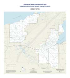
Generalized Water-Table Elevation Map in Agricultural Regions of Bayfield County, Wisconsin [plate 1]
2016
Map: 27 in x 30 in, scale 1:100,000
-
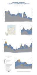
Hydrogeologic Cross Sections in Agricultural Regions of Bayfield County, Wisconsin [plate 2]
2016
Plate: 20 in x 40 in, scale 1:100,000
Related Collections
-

Technical Report
View Technical Report