-
Geology of the Baraboo Hills, Sauk and Columbia Counties, Wisconsin
Located in the south-central portion of the state, new geologic mapping of the frequently-visited Baraboo Hills has resulted in a revision of the stratigraphy of the Precambrian-aged bedrock. The Baraboo Quartzite is now divided into four informal members, and the maximum depositional age for the Baraboo Quartzite is 1714±17 million years old. These...-
Geology of the Baraboo Hills, Sauk and Columbia Counties, Wisconsin [plate 1]
2025
Map: 48.25 in x 29.25 in, scale 1:50,000
-
GIS Data for Geology of the Baraboo Hills, Sauk and Columbia Counties, Wisconsin [dataset 1]
2025
GIS Data: GeMS Level 3 file geodatabase (.gdb file format) and GeoPackage (.gpkg file fomat)
-
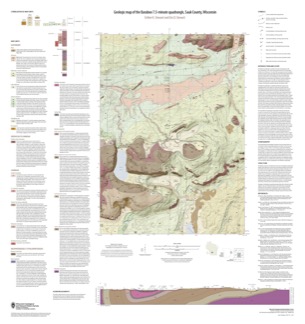
Geologic Map of the Durwards Glen 7.5-Minute Quadrangle, Columbia and Sauk Counties, Wisconsin
The Durwards Glen 7.5-minute quadrangle map is located in Columbia and Sauk counties, southeast of the city of Baraboo. This geologic map includes Precambrian through Quaternary units. New mapping has focused on subdividing the Baraboo Quartzite into four separate members and delineating Quaternary deposits in greater detail than prior work.-
Geologic Map of the Durwards Glen 7.5-Minute Quadrangle, Columbia and Sauk Counties, Wisconsin
2024
Map: 35 x 40 in, scale 1:24,000
-
GIS Data for the Geologic Map of the Durwards Glen 7.5-Minute Quadrangle, Columbia and Sauk Counties, Wisconsin [dataset 1]
2024
GIS Data: GeMS Level 3 file geodatabase (.gdb file format), shapefiles (.shp file format), GeoPackage (.gpkg file format)
-
-
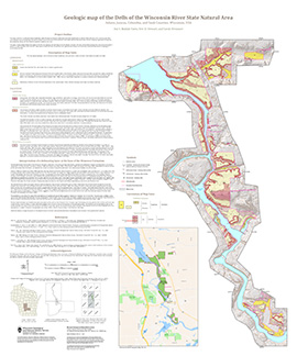
Geologic Map of the Dells of the Wisconsin River State Natural Area
The geologic map of the Dells of the Wisconsin River State Natural Area provides a detailed look at the bedrock geology present at one of Wisconsin's most cherished natural sites. The map and accompanying report present the Paleozoic bedrock stratigraphy of the visible formations, as well as an interpretation of their depositional environment. This map...-
Geologic Map of the Dells of the Wisconsin River State Natural Area
2023
Map: 30 x 36 in, scale 1:12,000
-
-
The Driftless Area: The extent of unglaciated and similar terrains in Wisconsin, Illinois, Iowa, and Minnesota
The Driftless Area of southwestern Wisconsin and northwestern Illinois got its name from the lack of glacial sediment ("drift") covering the landscape. The surficial geology and topography of the Driftless Area are thus distinct from the surrounding region where multiple phases of glaciation left their mark. This pamphlet, a collaborative effort between...-
GIS data for the outline of the Driftless Area and similar terrains in Wisconsin, Illinois, Iowa, and Minnesota
2023
GIS Data: Shapefiles (.shp file format)
-
Page-sized and web-version maps of the Driftless Area and similar terrains in Wisconsin, Illinois, Iowa, and Minnesota
2023
Map: Documents (.pdf file format), images (.tif file format)
-
Elevation contours of the Precambrian surface of south-central Wisconsin
Elevation contour data and an accompanying report provide an updated interpretation of the elevation of the top of Precambrian bedrock in south-central Wisconsin. The elevation surface was developed from geologic and geophysical data, and provides new detail on the entrenched bedrock valleys that were incised into the north and south ranges of the Baraboo...-
Elevation contours of the Precambrian surface of south-central Wisconsin [dataset 1]
2022
GIS Data: File geodatabase (.gdb file format)
-
-
Geologic Map of the Baraboo 7.5-Minute Quadrangle, Sauk County, Wisconsin
The Baraboo quadrangle, records where glaciers stopped in the east-central Baraboo Hills. On this map, 1:24,000 scale, Precambrian igneous and metasedimentary rocks are overlain by Paleozoic sedimentary rocks and, more recently, by glacial deposits. Superb exposures of all three can be found in Devils Lake State Park and Parfreys Glen State Natural Area.-
Geologic Map of the Baraboo 7.5-Minute Quadrangle, Sauk County, Wisconsin
2021
Map: 35 in x 37 in, scale 1:24,000
-
-
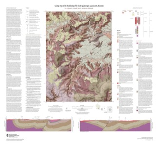
Geologic Map of the Rock Springs 7.5-Minute Quadrangle, Sauk County, Wisconsin
The Rock Springs quadrangle is located in the western Baraboo Hills of south-central Wisconsin. This map, 1:24,000 scale, conveys the rich Precambrian through Quaternary history present on the ground. Here, ancient rocks metamorphosed and folded and were later displaced by a series of faults. Although never glaciated, an ice sheet 8 kilometers to the east...-
Geologic Map of the Rock Springs 7.5-Minute Quadrangle, Sauk County, Wisconsin
2021
Map: 40 in x 36.5 in, scale 1:24,000
-
-
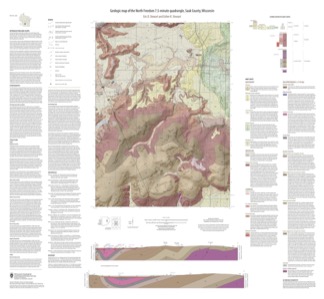
Geologic Map of the North Freedom 7.5-Minute Quadrangle, Sauk County, Wisconsin
The North Freedom quadrangle is located on the South Range of the Baraboo Hills in south-central Wisconsin. The Baraboo Hills are recognized for their ecologic and geologic significance, with superb exposure of Precambrian and Paleozoic rocks and Quaternary sediments. Mapping focused on the Precambrian section, building on past work by subdividing and...-
Geologic Map of the North Freedom 7.5-Minute Quadrangle, Sauk County, Wisconsin
2020
Map: 40 in x 37 in, scale 1:100,000
-
GIS Data for the Geologic Map of the North Freedom 7.5-Minute Quadrangle, Sauk County, Wisconsin (version 2) [dataset 1]
2020
GIS Data: GeMS file geodatabase (.gdb file format), shapefiles (.shp file format)
-
-
Geochemistry and Mineralogy of the Wonewoc-Tunnel City Contact Interval Strata in Western Wisconsin
Results of regional study characterizing the elemental composition of rocks found at the Wonewoc-Tunnel City contact interval in west-central and southwest Wisconsin.-
Geochemistry and Mineralogy of the Wonewoc-Tunnel City Contact Interval Strata in Western Wisconsin [appendices]
2019
Data: Documents (.pdf file format), spreadsheets (.xlsx file format)
-
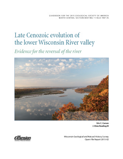
Late Cenozoic Evolution of the Lower Wisconsin River Valley: Evidence for the Reversal of the River
Field trip guidebook describes the evidence suggesting that the Wisconsin River once flowed from west to east. (Prepared for the 2015 Geological Society of America North-Central Section Meeting.) -
Forecasting Impacts of Extreme Precipitation Events on Wisconsin's Groundwater Levels
Open-file report; contains unpublished data that has not yet been peer-reviewed. -
Groundwater Sustainability in a Humid Climate: Groundwater Pumping, Groundwater Consumption, and Land-Use Change
Open-file report; contains unpublished data that has not yet been peer-reviewed. -
Delineation of Zones of Contribution for Municipal Wells in Sauk County, Wisconsin: Final Report
Open-file report; contains unpublished data that has not yet been peer-reviewed. -
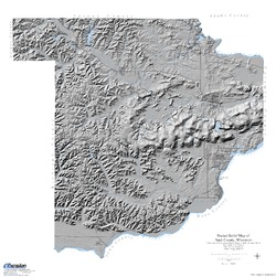
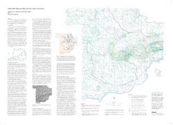
Shaded Relief Map of Sauk County, Wisconsin
Open-file report; contains unpublished data that has not yet been peer-reviewed. -
Merging Pleistocene Lithostratigraphy with Geotechnical and Hydrogeologic Data--Examples from Eastern Wisconsin
Open-file report; contains unpublished data that has not yet been peer-reviewed. -
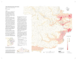
Discussion of the Phenomena of Local Glaciation in the Driftless Region
Open-file report; contains unpublished data that has not yet been peer-reviewed. -
Studies in the Driftless Region of Wisconsin
Open-file report; contains unpublished data that has not yet been peer-reviewed. -
Geology of Wisconsin - Outcrop Descriptions
These descriptions illustrate various geologic formations, features, and characteristics. Individual descriptions are one to ten pages long, and include a map with specific location, a description of geologic features, and a discussion of the geologic significance.-
Adams County: Upper Wisconsin Dells (T14N R6E Sec28)
Report: 3 p.
-
Adams County: Friendship Mound (T17N R6E Sec5)
Report: 2 p.
-
Adams County: Hamilton Mound (T20N R6E Sec36)
Report: 4 p.
-
Ashland County: Mt. Whittelsey (T44N R2W Sec9A)
Report: 3 p.
-
Ashland County: Mellen Gabbro (T45N R2W Sec30)
Report: 3 p.
-
Ashland County: Mellen Granite (T45N R2W Sec31)
Report: 3 p.
-
Ashland County: White River (T46N R4W Sec6)
Report: 2 p.
-
Bayfield County: South Fish Creek (T47N R5W Sec20)
Report: 2 p.
- 123 more...
-
-
Water-Table Elevation Map of Sauk County, Wisconsin
-
Water-Table Elevation Map of Sauk County, Wisconsin [GIS data]
2002
Map: Coverage (.e00 file format)

Publications Catalog
Wisconsin Geological and Natural History Survey