-
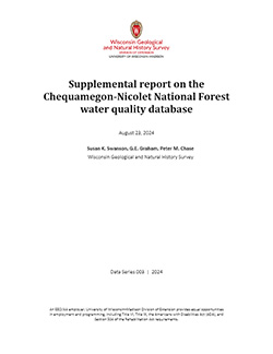
Chequamegon-Nicolet National Forest Water Quality Database
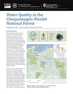
The Chequamegon-Nicolet National Forest (CNNF) in northern Wisconsin contains numerous groundwater-dependent water resources that may be vulnerable to potential effects of land development, mining, and climate change. In order to monitor water quality over time, 138 of the lakes, streams, wetlands, spring ponds, springs, and wells were sampled in...-
Chequamegon-Nicolet National Forest Water Quality Database
2024
Data: Spreadsheets (.csv file format)
-
-
Characterization of Groundwater Resources in the Chequamegon-Nicolet National Forest, Wisconsin
Results of a comprehensive review and analysis of groundwater resources in the Chequamegon-Nicolet National Forest. The study was divided by location into four reports corresponding to the four main land units: Medford, Nicolet, Park Falls, and Washburn/Great Divide. Each report describes the results of the inventory, modeling, and analysis.-
Characterization of Groundwater Resources in the Chequamegon-Nicolet National Forest, Wisconsin: Medford Unit [GIS data]
2018
GIS Data: File geodatabase (.gdb file format)
-
Characterization of Groundwater Resources in the Chequamegon-Nicolet National Forest, Wisconsin: Medford Unit [plates]
2018
Map: 10 maps, 11 in x 17 in
-
Characterization of Groundwater Resources in the Chequamegon-Nicolet National Forest, Wisconsin: Nicolet Unit [GIS data]
2018
GIS Data: File geodatabase (.gdb file format)
-
Characterization of Groundwater Resources in the Chequamegon-Nicolet National Forest, Wisconsin: Nicolet Unit [plates]
2018
Map: 20 maps (10 each, northern and southern Nicolet Unit), 11 in x 17 in
-
Characterization of Groundwater Resources in the Chequamegon-Nicolet National Forest, Wisconsin: Park Falls Unit [GIS data]
2018
GIS Data: File geodatabase (.gdb file format)
-
Characterization of Groundwater Resources in the Chequamegon-Nicolet National Forest, Wisconsin: Park Falls Unit [plates]
2018
Map: 10 maps, 11 in x 17 in
- 2 more...
-
Preliminary Quaternary Geologic Map of the Northern Fox River Lowland, Wisconsin
Open-file report; contains unpublished data that has not yet been peer-reviewed.-
Preliminary Quaternary Geologic Map of the Northern Fox River Lowland, Wisconsin
2007
Map: 42 in x 30.5 in, scale 1:100,000
-
-
Aggregate Resources of the Sinnipee Group in Eastern and Southern Wisconsin
Open-file report; contains unpublished data that has not yet been peer-reviewed. -
Compilation of Outcrops of Precambrian Rock in Northern Oconto County and Adjacent Segments of Forest, Langlade, Marinette, and Menominee Counties, Northeastern Wisconsin
Open-file report; contains unpublished data that has not yet been peer-reviewed. -
Merging Pleistocene Lithostratigraphy with Geotechnical and Hydrogeologic Data--Examples from Eastern Wisconsin
Open-file report; contains unpublished data that has not yet been peer-reviewed. -
Analytical Data of Precambrian Granitic Rock from Northeastern Wisconsin
Open-file report; contains unpublished data that has not yet been peer-reviewed. -
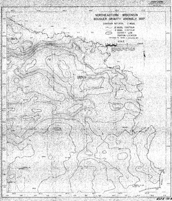
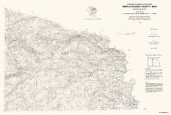
Bouguer Gravity Anomaly Map of Northeastern Wisconsin
Open-file report; contains unpublished data that has not yet been peer-reviewed. -
Field Report, Glacial Geology of Outagamie, Shawano, Oconto, and Langlade Counties
Open-file report; contains unpublished data that has not yet been peer-reviewed. -
Bedrock Geology of Wisconsin, Northeast Sheet
Types of bedrock, formation names, major faults, and time period of formation.-
Bedrock Geology of Wisconsin, Northeast Sheet [GIS data]
1984
GIS Data: GeMS file geodatabase (.gdb file format)
-
A Subsurface Study of the St. Peter Sandstone in Southern and Eastern Wisconsin
-
Structure Contour Map of the Pre-St. Peter Sandstone Erosion Surface in Southern and Eastern Wisconsin [plate 1]
1985
Map: 39.7 in x 23.5 in, scale 1:750,000
-
Paleogeologic Map of the Pre-St. Peter Sandstone Surface in Southern and Eastern Wisconsin & Thickness Map of the St. Peter Sandstone in Southern and Eastern Wisconsin [plate 2]
1985
Map: 39.4 in x 23.6 in, scale 1:750,000
-
Geoscience Wisconsin Volume 13
-
Precambrian Metamorphism in the Southern Lake Superior Region and Its Bearing on Crustal Evolution
1989
Journal Article: p. 1-33
-
U.S. Department of Energy Publications on Uranium and Radiometric Surveys of Wisconsin
1989
Journal Article: p. 62-66
-
Geoscience Wisconsin Volume 12
-
Subsurface Stratigraphic Relationships of the Upper Silurian and Devonian Rock of Milwaukee County, Wisconsin
1988
Journal Article: p. 1-23
-
Petrochemistry of Precambrian Granitic Rock from Northeastern Wisconsin
1988
Journal Article: p. 45-61
-
Seismic Refraction Measurements in Bedrock of the Trout Lake Region of Vilas County, Northern Wisconsin
1988
Journal Article: p. 63-76
-
Seasonal Geochemistry of Two Tufa-Depositing Springs in Southwestern Wisconsin
1988
Journal Article: p. 77-83
-
Geoscience Wisconsin Volume 08
-
The Pleistocene Stratigraphy and Geomorphology of Central-Southern Wisconsin and Part of Northern Illinois
1983
Journal Article: p. 22-44
-
Geophysical Evidence That the Haeger Till Member Underlies Southern Western Lake Michigan
1983
Journal Article: p. 45-58
-
Atlas of the Geological Survey of Wisconsin
Collection of most of the plates accompanying Chamberlin's four-volume Geology of Wisconsin: Survey of 1873-1879.-
Atlas of the Geological Survey of Wisconsin: General Geological Map of Wisconsin [plate 1]
1882
Map: 25.5 in x 30.3 in, scale 1 in = 15 miles
-
Atlas of the Geological Survey of Wisconsin: General Map of Quaternary Formations [plate 2]
1882
Map: 28.2 in x 32.4 in
-
Atlas of the Geological Survey of Wisconsin: General Map of Native Vegetation [plate 2A]
1882
Map: 28.2 in x 32.4 in
-
Atlas of the Geological Survey of Wisconsin: General Map of Soils [plate 2B]
1882
Map: 28.2 in x 32.5 in
-
Atlas of the Geological Survey of Wisconsin: Map of Rainfall and Temperature [plate 2C]
1882
Map: 27.7 in x 32.5 in
-
Atlas of the Geological Survey of Wisconsin: Maps of Subsoils and Native Vegetation of Eastern Wisconsin [plate 3]
1877
Map: 27.82 in x 32.17 in, scale 1 in = 12 miles
-
Atlas of the Geological Survey of Wisconsin: Maps of Topography and Quaternary Formations of Eastern Wisconsin [plate 4]
1877
Map: 27.83 in x 32.06 in, scale 1 in = 12 miles
-
Atlas of the Geological Survey of Wisconsin: Geology and Topography of the Lead Region [plate 5]
1877
Map: 27.68 in x 32.18 in
-
Atlas of the Geological Survey of Wisconsin: Geology and Topography of the Lead Region [plate 6]
1877
Map: 23.98 in x 28.94 in
-
Atlas of the Geological Survey of Wisconsin: Geology and Topography of the Lead Region [plate 8]
1877
Map: 24.03 in x 28.38 in
- 32 more...
-
-
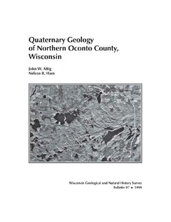
Quaternary Geology of Northern Oconto County, Wisconsin
-
Quaternary Geology of Northern Oconto County, Wisconsin (version 2) [GIS data]
1999
GIS Data: GeMS file geodatabase (.gdb file format)
-
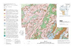
Quaternary Geologic Map of Northern Oconto County, Wisconsin [plate 1]
1999
Map: 24 in x 15.5 in, scale 1:100,000

Publications Catalog
Wisconsin Geological and Natural History Survey