-
Geology of Wisconsin - Outcrop Descriptions
These descriptions illustrate various geologic formations, features, and characteristics. Individual descriptions are one to ten pages long, and include a map with specific location, a description of geologic features, and a discussion of the geologic significance.-
Adams County: Upper Wisconsin Dells (T14N R6E Sec28)
Report: 3 p.
-
Adams County: Friendship Mound (T17N R6E Sec5)
Report: 2 p.
-
Adams County: Hamilton Mound (T20N R6E Sec36)
Report: 4 p.
-
Ashland County: Mt. Whittelsey (T44N R2W Sec9A)
Report: 3 p.
-
Ashland County: Mellen Gabbro (T45N R2W Sec30)
Report: 3 p.
-
Ashland County: Mellen Granite (T45N R2W Sec31)
Report: 3 p.
-
Ashland County: White River (T46N R4W Sec6)
Report: 2 p.
-
Bayfield County: South Fish Creek (T47N R5W Sec20)
Report: 2 p.
- 123 more...
-
-
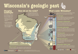
Wisconsin's Geologic Past
At different times in the past three billion years, mountains and volcanoes stood tall in Wisconsin, shallow seas covered much of the state, and glaciers plowed across the landscape. This educational poster vividly brings our past to life. Ideal for classrooms. Size: 27 x 39 inches. -
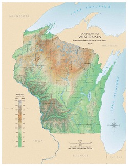
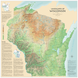
Landscapes of Wisconsin
Shows the elevation of Wisconsin through the use of color and shaded relief. Includes explanatory text about the geologic history of the state and more detailed information about 12 of the most prominent features. Poster map scale 1:500,000. Size: 42 x 42 inches. -
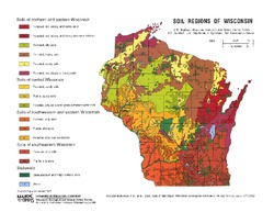
Soil Regions of Wisconsin
Shows 15 general soil regions of Wisconsin. On the landscape, many of these regions appear distinctly different from each other because differences in land form and use are often related to the characteristics of the soils. -
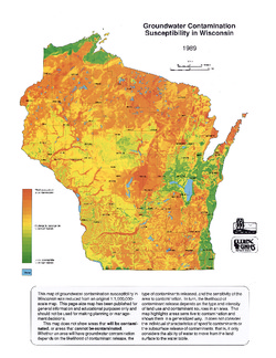
Groundwater Contamination Susceptibility in Wisconsin
How susceptible are different areas of Wisconsin to groundwater contamination? This map gives a quick visual overview. It was created using type of bedrock, depth to bedrock, depth to water table, soil type, and surface deposits. -
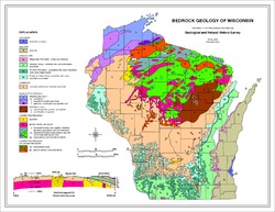
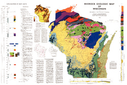
Bedrock Geologic Map of Wisconsin
Describes the types of rocks found throughout the state by age and explains how to interpret the accompanying cross section.-
Bedrock Geologic Map of Wisconsin [GIS data]
1982
GIS Data: MrSID files (.sid file format), coverage (.e00 file format)
-
Original Vegetation Cover of Wisconsin
Based on the original land-survey records compiled between 1832 and 1866. Also available as set with Wisconsin Land Cover map. -
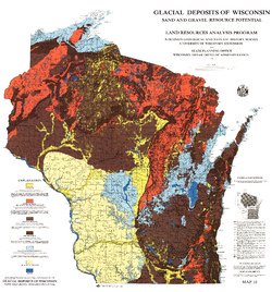
Glacial Deposits of Wisconsin: Sand and Gravel Resource Potential
Color map showing outwash, ground moraine, end moraine, and glacial deposits.-
Glacial Deposits of Wisconsin: Sand and Gravel Resource Potential
1976
Map: 45 in x 43.25 in, scale 1:500,000
-

Publications Catalog
Wisconsin Geological and Natural History Survey