-
Depth to Silurian Bedrock in Eastern Wisconsin
Silurian-aged bedrock in eastern Wisconsin is shallow, fractured, and contains groundwater that is susceptible to surface water contamination. Revisions to Wisconsin state rules ATCP50 and NR151 to regulate manure spreading over this Silurian-aged bedrock create the need for a depth-to-bedrock map of eastern WI. The Wisconsin Geological and Natural...-
Depth to Silurian Bedrock in Eastern Wisconsin [dataset 1]
2025
GIS Data: File geodatabase, metadata
-
-
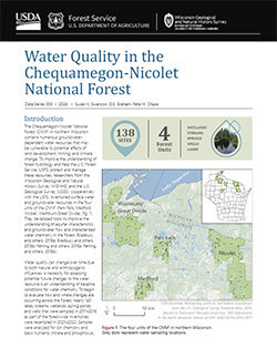
Chequamegon-Nicolet National Forest Water Quality Database
The Chequamegon-Nicolet National Forest (CNNF) in northern Wisconsin contains numerous groundwater-dependent water resources that may be vulnerable to potential effects of land development, mining, and climate change. In order to monitor water quality over time, 138 of the lakes, streams, wetlands, spring ponds, springs, and wells were sampled in... -
Geologic map of the Stitzer and western part of the Montfort 7.5-minute quadrangles, Grant County, Wisconsin
The geologic map of the Stitzer and western part of the Montfort quadrangles includes 1:24,000-scale mapping of both surficial and bedrock geology. This area occurs at the northern margin of the historic Upper Mississippi Valley lead and zinc mining district. Paleozoic strata are folded into a regionally-significant anticline, and mapping was initiated to...-
Geologic map of the Stitzer and western part of the Montfort 7.5-minute quadrangles, Grant County, Wisconsin
2023
Map: 46.15 in x 36 in, scale 1:24,000
-
GIS data for geologic map of the Stitzer and western part of the Montfort 7.5-minute quadrangles, Grant County, Wisconsin [dataset 1]
2023
GIS Data: GeMS file geodatabase, shapefiles, metadata
-
-
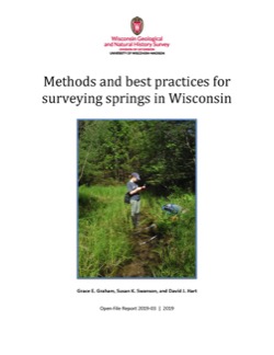
Methods and Best Practices for Surveying Springs in Wisconsin
Description of the field methods and data management procedures used to produce the Springs Inventory (see Bulletin 113). -
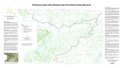
Preliminary Water-Table Elevation Map of Columbia County, Wisconsin
Open-file report; contains unpublished data that has not yet been peer-reviewed.-
Preliminary Water-Table Elevation Map of Columbia County, Wisconsin
2012
Map: 36 in x 20 in, scale 1:100,000
-
Preliminary Water-Table Elevation Map of Columbia County, Wisconsin [GIS data]
2012
GIS Data: Shapefiles
-
-
Distributed Temperature Sensing (DTS) as a Hydrostratigraphic Characterization Tool
Open-file report; contains unpublished data that has not yet been peer-reviewed. -
Assessment of Virus Presence and Potential Virus Pathways in Deep Municipal Wells
Open-file report; contains unpublished data that has not yet been peer-reviewed. -
Mineral Transformation and Release of Arsenic to Solution under the Oxidizing Conditions of Well Disinfection
Open-file report; contains unpublished data that has not yet been peer-reviewed. -
Inventory of Wisconsin's Springs
Open-file report; contains unpublished data that has not yet been peer-reviewed. -
A Local Meteoric Water Line for Madison, Wisconsin
Open-file report; contains unpublished data that has not yet been peer-reviewed. -
Reflooded Mine Source Term Technical Memoranda for the Proposed Crandon Mine, Forest County, Wisconsin
Open-file report; contains unpublished data that has not yet been peer-reviewed. -
Evaluation of the Reflooded Mine Solute Transport Model Developed for the Proposed Crandon Mine, Forest County, Wisconsin
Open-file report; contains unpublished data that has not yet been peer-reviewed. -
Delineation of Five-Year Zones of Contribution for Municipal Wells in LaCrosse County, Wisconsin
Open-file report; contains unpublished data that has not yet been peer-reviewed. -
Delineation of Zones of Contribution for Municipal Wells in Sauk County, Wisconsin: Final Report
Open-file report; contains unpublished data that has not yet been peer-reviewed.-
Delineation of Zones of Contribution for Municipal Wells in Sauk County, Wisconsin
2002
Report: 74 p. + 2 plates
-
-
Delineation of Zones of Contribution for Municipal Wells in Rock County, Wisconsin: Final Report
Open-file report; contains unpublished data that has not yet been peer-reviewed.

Publications Catalog
Wisconsin Geological and Natural History Survey