-
Depth-to-Bedrock Mapping in Wisconsin
Depth-to-bedrock maps show the thickness of unconsolidated materials overlying bedrock. These maps provide a key link between the underlying geology, groundwater flow, and land use and are important in guiding activities such as permitting, bridge construction, and the land application of waste products in sensitive areas. Given their role in guiding... -
Depth-to-Bedrock Map of Dodge County, Wisconsin
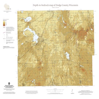
This map shows thicknesses of deposits of unconsolidated materials above the bedrock. Across the county, depth to bedrock ranges from 0 feet, where bedrock is exposed, to over 250 feet within bedrock valleys. Areas with bedrock depths shallower than 20 feet are of particular importance for land-use planning and to the construction stone industry. Such...

Publications Catalog
Wisconsin Geological and Natural History Survey