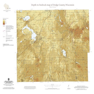
This map shows thicknesses of deposits of unconsolidated materials above the bedrock. Across the county, depth to bedrock ranges from 0 feet, where bedrock is exposed, to over 250 feet within bedrock valleys. Areas with bedrock depths shallower than 20 feet are of particular importance for land-use planning and to the construction stone industry. Such areas are more susceptible to groundwater contamination and underlie about 17 percent of Dodge County, including the more-populated areas of the county. The accompanying report describes how the map was compiled and outlines limitations of the map. [Companion to Bedrock Geology of Dodge County, Wisconsin (M508).]