-
Geology of the Baraboo Hills, Sauk and Columbia Counties, Wisconsin
Located in the south-central portion of the state, new geologic mapping of the frequently-visited Baraboo Hills has resulted in a revision of the stratigraphy of the Precambrian-aged bedrock. The Baraboo Quartzite is now divided into four informal members, and the maximum depositional age for the Baraboo Quartzite is 1714±17 million years old. These...-
Geology of the Baraboo Hills, Sauk and Columbia Counties, Wisconsin [plate 1]
2025
Map: 48.25 in x 29.25 in, scale 1:50,000
-
GIS Data for Geology of the Baraboo Hills, Sauk and Columbia Counties, Wisconsin [dataset 1]
2025
GIS Data: GeMS Level 3 file geodatabase (.gdb file format) and GeoPackage (.gpkg file fomat)
-
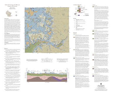
Bedrock Geology of Jefferson County, Wisconsin
Located in southeast Wisconsin, Jefferson County is almost entirely blanketed by sediments that were delivered or shaped by the ice sheet that covered this area during the last ice age. New mapping interprets the distribution of the bedrock surface that is buried beneath those glacial sediments as interpreted by three drill cores, over 13,000 well...-
GIS Data for the Bedrock Geology of Jefferson County, Wisconsin [dataset 1]
2024
GIS Data: GeMS Level 3 file geodatabase (.gdb file format), shapefiles (.shp file format), GeoPackage (.gpkg file format)
-
Bedrock Elevation Raster for the Bedrock Geology of Jefferson County, Wisconsin [dataset 2]
2024
GIS Data: File geodatabase (.gdb file format)
-
Geochemical Data for the Bedrock Geology of Jefferson County, Wisconsin [dataset 3]
2024
Data: Spreadsheets (.xlsx file format)
-
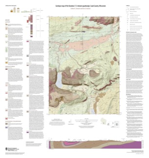
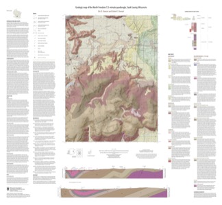
Geologic Map of the Durwards Glen 7.5-Minute Quadrangle, Columbia and Sauk Counties, Wisconsin
The Durwards Glen 7.5-minute quadrangle map is located in Columbia and Sauk counties, southeast of the city of Baraboo. This geologic map includes Precambrian through Quaternary units. New mapping has focused on subdividing the Baraboo Quartzite into four separate members and delineating Quaternary deposits in greater detail than prior work.-
Geologic Map of the Durwards Glen 7.5-Minute Quadrangle, Columbia and Sauk Counties, Wisconsin
2024
Map: 35 x 40 in, scale 1:24,000
-
GIS Data for the Geologic Map of the Durwards Glen 7.5-Minute Quadrangle, Columbia and Sauk Counties, Wisconsin [dataset 1]
2024
GIS Data: GeMS Level 3 file geodatabase (.gdb file format), shapefiles (.shp file format), GeoPackage (.gpkg file format)
-
-
Evaluating pXRF instrument performance using reference materials
The portable X-Ray Fluorescence (pXRF) instrument provides fast, real-time, non-destructive, multi-element geochemical data (i.e. elemental concentrations) on rocks and minerals at a relatively low cost and with minimal sample preparation. This study quantifies the precision and accuracy of measurements collected by the WGNHS pXRF on reference materials... -
Elevation contours of the Precambrian surface of south-central Wisconsin
Elevation contour data and an accompanying report provide an updated interpretation of the elevation of the top of Precambrian bedrock in south-central Wisconsin. The elevation surface was developed from geologic and geophysical data, and provides new detail on the entrenched bedrock valleys that were incised into the north and south ranges of the Baraboo...-
Elevation contours of the Precambrian surface of south-central Wisconsin [dataset 1]
2022
GIS Data: File geodatabase (.gdb file format)
-
-
Mineral Assessments for Conservation Easements in Wisconsin
If you’re thinking about donating land as a conservation easement but don’t own the subsurface (known as “severed mineral rights”), then you’ll need an assessment of the land’s mineral potential to determine whether the easement will qualify as a charitable tax deduction. Geologists at the Wisconsin Geological and Natural History Survey perform this... -
Depth-to-Bedrock Mapping in Wisconsin
Depth-to-bedrock maps show the thickness of unconsolidated materials overlying bedrock. These maps provide a key link between the underlying geology, groundwater flow, and land use and are important in guiding activities such as permitting, bridge construction, and the land application of waste products in sensitive areas. Given their role in guiding... -
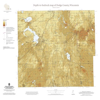
Depth-to-Bedrock Map of Dodge County, Wisconsin
This map shows thicknesses of deposits of unconsolidated materials above the bedrock. Across the county, depth to bedrock ranges from 0 feet, where bedrock is exposed, to over 250 feet within bedrock valleys. Areas with bedrock depths shallower than 20 feet are of particular importance for land-use planning and to the construction stone industry. Such... -
Geologic Map of the Baraboo 7.5-Minute Quadrangle, Sauk County, Wisconsin
The Baraboo quadrangle, records where glaciers stopped in the east-central Baraboo Hills. On this map, 1:24,000 scale, Precambrian igneous and metasedimentary rocks are overlain by Paleozoic sedimentary rocks and, more recently, by glacial deposits. Superb exposures of all three can be found in Devils Lake State Park and Parfreys Glen State Natural Area.-
Geologic Map of the Baraboo 7.5-Minute Quadrangle, Sauk County, Wisconsin
2021
Map: 35 in x 37 in, scale 1:24,000
-
-
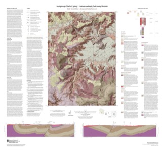
Geologic Map of the Rock Springs 7.5-Minute Quadrangle, Sauk County, Wisconsin
The Rock Springs quadrangle is located in the western Baraboo Hills of south-central Wisconsin. This map, 1:24,000 scale, conveys the rich Precambrian through Quaternary history present on the ground. Here, ancient rocks metamorphosed and folded and were later displaced by a series of faults. Although never glaciated, an ice sheet 8 kilometers to the east...-
Geologic Map of the Rock Springs 7.5-Minute Quadrangle, Sauk County, Wisconsin
2021
Map: 40 in x 36.5 in, scale 1:24,000
-
-
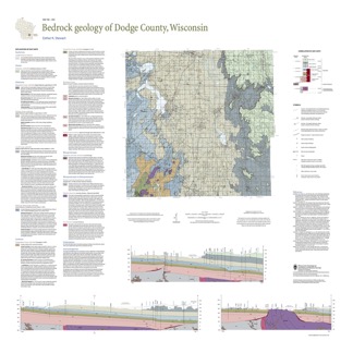
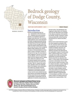
Bedrock Geology of Dodge County, Wisconsin
Dodge County lies in southeast Wisconsin, an area almost entirely covered by glacial deposits. This map interprets the distribution of the buried bedrock units across the county. Geologist Esther Stewart’s refinement of the bedrock elevation contours may help land-use planners identify areas most susceptible to groundwater contamination from applications...-
Supporting Data for the Bedrock Geology of Dodge County, Wisconsin
2021
Data: Spreadsheets (.xlsx file format)
-
GIS Data for the Bedrock Geology of Dodge County, Wisconsin [dataset 2]
2021
GIS Data: GeMS Level 3 file geodatabase (.gdb file format), shapefiles (.shp file format), GeoPackage (.gpkg file format)
-
Geologic Map of the North Freedom 7.5-Minute Quadrangle, Sauk County, Wisconsin
The North Freedom quadrangle is located on the South Range of the Baraboo Hills in south-central Wisconsin. The Baraboo Hills are recognized for their ecologic and geologic significance, with superb exposure of Precambrian and Paleozoic rocks and Quaternary sediments. Mapping focused on the Precambrian section, building on past work by subdividing and...-
Geologic Map of the North Freedom 7.5-Minute Quadrangle, Sauk County, Wisconsin
2020
Map: 40 in x 37 in, scale 1:100,000
-
GIS Data for the Geologic Map of the North Freedom 7.5-Minute Quadrangle, Sauk County, Wisconsin (version 2) [dataset 1]
2020
GIS Data: GeMS file geodatabase (.gdb file format), shapefiles (.shp file format)
-
-
Sampling Methodologies and Data Analysis Techniques for Geologic Materials Using Portable X-Ray Fluorescence (pXRF) Elemental Analysis
Details the current WGNHS approach to pXRF analysis, including usage guidelines, sample preparation, calibration, and plotting techniques.-
Sampling Methodologies and Data Analysis Techniques for Geologic Materials Using Portable X-Ray Fluorescence (pXRF) Elemental Analysis [appendices]
2016
Data: Documents (.pdf file format), spreadsheets (.xlsx file format)

Publications Catalog
Wisconsin Geological and Natural History Survey