-
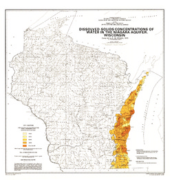
Dissolved-Solids Concentrations of Water in the Niagara Aquifer, Wisconsin
-
Dissolved-Solids Concentrations of Water in the Niagara Aquifer, Wisconsin
1975
Map: 23 in x 24 in, scale 1:1,000,000
-
-
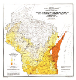
Dissolved-Solids Concentrations of Water in the Sandstone Aquifer, Wisconsin
-
Dissolved-Solids Concentrations of Water in the Sandstone Aquifer, Wisconsin
1975
Map: 23 in x 24 in, scale 1:1,000,000
-
-
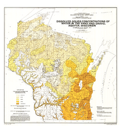
Dissolved-Solids Concentrations of Water in the Sand-and-Gravel Aquifer, Wisconsin
-
Dissolved-Solids Concentrations of Water in the Sand-and-Gravel Aquifer, Wisconsin
1975
Map: 23 in x 24.5 in, scale 1:1,000,000
-
-
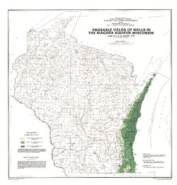
Probable Yields of Wells in the Niagara Aquifer, Wisconsin
-
Probable Yields of Wells in the Niagara Aquifer, Wisconsin
1975
Map: 23 in x 24 in, scale 1:1,000,000
-
-
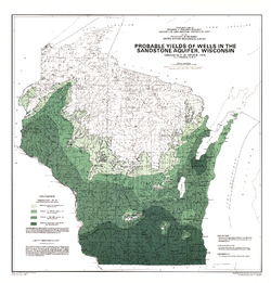
Probable Yields of Wells in the Sandstone Aquifer, Wisconsin
-
Probable Yields of Wells in the Sandstone Aquifer, Wisconsin
1975
Map: 23 in x 24 in, scale 1:1,000,000
-
-
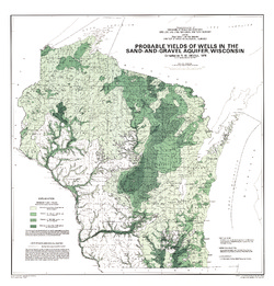
Probable Yields of Wells in the Sand-and-Gravel Aquifer, Wisconsin
-
Probable Yields of Wells in the Sand-and-Gravel Aquifer, Wisconsin
1975
Map: 23 in x 24 in, scale 1:1,000,000
-
-
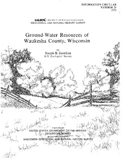
Ground-Water Resources of Waukesha County, Wisconsin
-
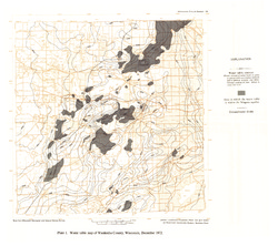
Water Table Map of Waukesha County, Wisconsin, December 1972 [plate 1]
1975
Map: 18 in x 16 in, scale 1:125,000

Publications Catalog
Wisconsin Geological and Natural History Survey