-
Preliminary Geologic Map of the Buried Bedrock Surface, Brown County, Wisconsin
Open-file report; contains unpublished data that has not yet been peer-reviewed.-
Preliminary Geologic Map of the Buried Bedrock Surface, Brown County, Wisconsin
2011
Map: 26 in x 30 in, scale 1:100,000
-
-
Preliminary Quaternary Geologic Map of the Northern Fox River Lowland, Wisconsin
Open-file report; contains unpublished data that has not yet been peer-reviewed.-
Preliminary Quaternary Geologic Map of the Northern Fox River Lowland, Wisconsin
2007
Map: 42 in x 30.5 in, scale 1:100,000
-
-
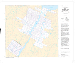
Green Bay Area Private Claims and Williams Grant Subdivision in Brown County, Wisconsin
-
Green Bay Area Private Claims and Williams Grant Subdivision in Brown County, Wisconsin
1997
Map: 30.8 in x 25.9 in, scale 1:36,000
-
-
Hydrogeology and Ground-Water Use and Quality, Brown County, Wisconsin
-
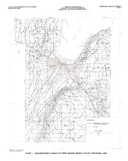
Potentiometric Surface of Upper Aquifer, Brown County, Wisconsin, 1980 [plate 1]
1986
Map: 20 in x 25 in, scale 1:100,000
-
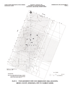
Finite-Difference Grid and Observation Well Locations, Brown County, Wisconsin, Used to Calibrate Model [plate 2]
1986
Map: 16 in x 19 in, scale 1:500,000
-
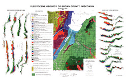
Pleistocene Geology of Brown County, Wisconsin
-
Pleistocene Geology of Brown County, Wisconsin [GIS data]
1985
GIS Data: Shapefiles (.shp file format), MrSID files (.sid file format)
-
A Subsurface Study of the St. Peter Sandstone in Southern and Eastern Wisconsin
-
Structure Contour Map of the Pre-St. Peter Sandstone Erosion Surface in Southern and Eastern Wisconsin [plate 1]
1985
Map: 39.7 in x 23.5 in, scale 1:750,000
-
Paleogeologic Map of the Pre-St. Peter Sandstone Surface in Southern and Eastern Wisconsin & Thickness Map of the St. Peter Sandstone in Southern and Eastern Wisconsin [plate 2]
1985
Map: 39.4 in x 23.6 in, scale 1:750,000
-
Atlas of the Geological Survey of Wisconsin
Collection of most of the plates accompanying Chamberlin's four-volume Geology of Wisconsin: Survey of 1873-1879.-
Atlas of the Geological Survey of Wisconsin: General Geological Map of Wisconsin [plate 1]
1882
Map: 25.5 in x 30.3 in, scale 1 in = 15 miles
-
Atlas of the Geological Survey of Wisconsin: General Map of Quaternary Formations [plate 2]
1882
Map: 28.2 in x 32.4 in
-
Atlas of the Geological Survey of Wisconsin: General Map of Native Vegetation [plate 2A]
1882
Map: 28.2 in x 32.4 in
-
Atlas of the Geological Survey of Wisconsin: General Map of Soils [plate 2B]
1882
Map: 28.2 in x 32.5 in
-
Atlas of the Geological Survey of Wisconsin: Map of Rainfall and Temperature [plate 2C]
1882
Map: 27.7 in x 32.5 in
-
Atlas of the Geological Survey of Wisconsin: Maps of Subsoils and Native Vegetation of Eastern Wisconsin [plate 3]
1877
Map: 27.82 in x 32.17 in, scale 1 in = 12 miles
-
Atlas of the Geological Survey of Wisconsin: Maps of Topography and Quaternary Formations of Eastern Wisconsin [plate 4]
1877
Map: 27.83 in x 32.06 in, scale 1 in = 12 miles
-
Atlas of the Geological Survey of Wisconsin: Geology and Topography of the Lead Region [plate 5]
1877
Map: 27.68 in x 32.18 in
-
Atlas of the Geological Survey of Wisconsin: Geology and Topography of the Lead Region [plate 6]
1877
Map: 23.98 in x 28.94 in
-
Atlas of the Geological Survey of Wisconsin: Geology and Topography of the Lead Region [plate 8]
1877
Map: 24.03 in x 28.38 in
- 32 more...
-

Publications Catalog
Wisconsin Geological and Natural History Survey