-
The Driftless Area: The extent of unglaciated and similar terrains in Wisconsin, Illinois, Iowa, and Minnesota
The Driftless Area of southwestern Wisconsin and northwestern Illinois got its name from the lack of glacial sediment ("drift") covering the landscape. The surficial geology and topography of the Driftless Area are thus distinct from the surrounding region where multiple phases of glaciation left their mark. This pamphlet, a collaborative effort between...-
GIS data for the outline of the Driftless Area and similar terrains in Wisconsin, Illinois, Iowa, and Minnesota
2023
GIS Data: Shapefiles (.shp file format)
-
Page-sized and web-version maps of the Driftless Area and similar terrains in Wisconsin, Illinois, Iowa, and Minnesota
2023
Map: Documents (.pdf file format), images (.tif file format)
-
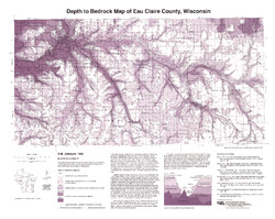
Generalized Water-Table Elevation of Eau Claire County, Wisconsin
-
Generalized Water-Table Elevation Map of Eau Claire County, Wisconsin
1992
Map: 24.5 in x 25 in, scale 1:100,000
-
-
Bedrock Geology of Wisconsin, West-Central Sheet
Types of bedrock, formation names, major faults, and time period of formation.-
Bedrock Geology of Wisconsin, West-Central Sheet [GIS data]
1988
GIS Data: GeMS file geodatabase (.gdb file format)
-
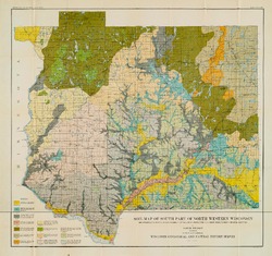
Atlas of the Geological Survey of Wisconsin
Collection of most of the plates accompanying Chamberlin's four-volume Geology of Wisconsin: Survey of 1873-1879.-
Atlas of the Geological Survey of Wisconsin: General Geological Map of Wisconsin [plate 1]
1882
Map: 25.5 in x 30.3 in, scale 1 in = 15 miles
-
Atlas of the Geological Survey of Wisconsin: General Map of Quaternary Formations [plate 2]
1882
Map: 28.2 in x 32.4 in
-
Atlas of the Geological Survey of Wisconsin: General Map of Native Vegetation [plate 2A]
1882
Map: 28.2 in x 32.4 in
-
Atlas of the Geological Survey of Wisconsin: General Map of Soils [plate 2B]
1882
Map: 28.2 in x 32.5 in
-
Atlas of the Geological Survey of Wisconsin: Map of Rainfall and Temperature [plate 2C]
1882
Map: 27.7 in x 32.5 in
-
Atlas of the Geological Survey of Wisconsin: Maps of Subsoils and Native Vegetation of Eastern Wisconsin [plate 3]
1877
Map: 27.82 in x 32.17 in, scale 1 in = 12 miles
-
Atlas of the Geological Survey of Wisconsin: Maps of Topography and Quaternary Formations of Eastern Wisconsin [plate 4]
1877
Map: 27.83 in x 32.06 in, scale 1 in = 12 miles
-
Atlas of the Geological Survey of Wisconsin: Geology and Topography of the Lead Region [plate 5]
1877
Map: 27.68 in x 32.18 in
-
Atlas of the Geological Survey of Wisconsin: Geology and Topography of the Lead Region [plate 6]
1877
Map: 23.98 in x 28.94 in
-
Atlas of the Geological Survey of Wisconsin: Geology and Topography of the Lead Region [plate 8]
1877
Map: 24.03 in x 28.38 in
- 32 more...
-

Publications Catalog
Wisconsin Geological and Natural History Survey