-
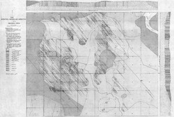
Syenites and Nepheline Syenites of the Wausau Area
Open-file report; contains unpublished data that has not yet been peer-reviewed.-
Syenites and Nepheline Syenites of the Wausau Area
1945
Map: 54 in x 36.4 in, scale 1 in = 1,000 feet
-
Irrigable Lands Inventory--Phase I Groundwater and Related Information
This paper contains hydrogeologic information for the Golden Sands Resource Conservation and Development Area in central Wisconsin. The set of maps includes water-table elevation maps for the following counties: Adams, Jackson, Juneau, Marathon, Marquette, Monroe, Portage, Waupaca, Waushara, and Wood (scale 1:126,720). It also includes a regional aquifer...-
Irrigable Lands Inventory - Phase I Groundwater and Related Information
1981
Report: 13 p., 11 maps, scale 1:126,720 and 1:500,000
- 2 more...
-
-
Bedrock Geology of Wisconsin, West-Central Sheet
Types of bedrock, formation names, major faults, and time period of formation.-
Bedrock Geology of Wisconsin, West-Central Sheet [GIS data]
1988
GIS Data: GeMS file geodatabase (.gdb file format)
-
Bedrock Geology of Wisconsin, Northwest Sheet
Types of bedrock, formation names, major faults, and time period of formation.-
Bedrock Geology of Wisconsin, Northwest Sheet
1987
Map: 37.5 in x 22 in, scale 1:250,000; 35.5 in x 20 in
-
Bedrock Geology of Wisconsin, Northwest Sheet [GIS data]
1987
GIS Data: MrSID files (.sid file format)
-
-
Bedrock Geology of Wisconsin, Northeast Sheet
Types of bedrock, formation names, major faults, and time period of formation.-
Bedrock Geology of Wisconsin, Northeast Sheet [GIS data]
1984
GIS Data: GeMS file geodatabase (.gdb file format)
-
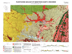
Pleistocene Geology of Marathon County, Wisconsin
-
Pleistocene Geology of Marathon County, Wisconsin (version 3) [GIS data]
1989
GIS Data: GeMS Level 3 file geodatabase (.gdb file format)
-
Pleistocene Geology of Marathon County, Wisconsin [plate 1]
1989
Map: 37.5 in x 28 in, scale 1:100,000
-
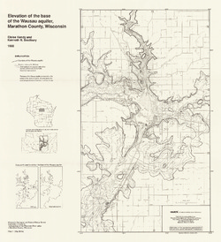
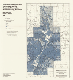
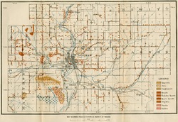
Hydrogeology of the Wisconsin River Valley in Marathon County, Wisconsin
-
Elevation of the Base of the Wausau Aquifer, Marathon County, Wisconsin [plate 1]
1988
Map: 21.3 in x 23.3 in, scale 1:100,000
-
Elevation of the Water Table in the Wisconsin River Valley, Marathon County, Wisconsin [plate 2]
1988
Map: 21.3 in x 23.4 in, scale 1:100,000
-
Attenuation Potential of Soils Overlying Parts of the Wisconsin River Valley, Marathon County, Wisconsin [plate 3]
1988
Map: 21.4 in x 23.3 in, scale 1:100,000
-
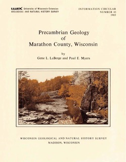
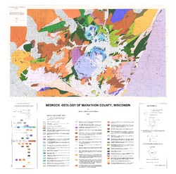
Precambrian Geology of Marathon County, Wisconsin
-
GIS Data for the Precambrian Geology of Marathon County, Wisconsin (version 2) [dataset 1]
1983
GIS Data: GeMS Level 3 file geodatabase (.gdb file format), shapefiles (.shp file format), GeoPackage (.gpkg file format)
-
Atlas of the Geological Survey of Wisconsin
Collection of most of the plates accompanying Chamberlin's four-volume Geology of Wisconsin: Survey of 1873-1879.-
Atlas of the Geological Survey of Wisconsin: General Geological Map of Wisconsin [plate 1]
1882
Map: 25.5 in x 30.3 in, scale 1 in = 15 miles
-
Atlas of the Geological Survey of Wisconsin: General Map of Quaternary Formations [plate 2]
1882
Map: 28.2 in x 32.4 in
-
Atlas of the Geological Survey of Wisconsin: General Map of Native Vegetation [plate 2A]
1882
Map: 28.2 in x 32.4 in
-
Atlas of the Geological Survey of Wisconsin: General Map of Soils [plate 2B]
1882
Map: 28.2 in x 32.5 in
-
Atlas of the Geological Survey of Wisconsin: Map of Rainfall and Temperature [plate 2C]
1882
Map: 27.7 in x 32.5 in
-
Atlas of the Geological Survey of Wisconsin: Maps of Subsoils and Native Vegetation of Eastern Wisconsin [plate 3]
1877
Map: 27.82 in x 32.17 in, scale 1 in = 12 miles
-
Atlas of the Geological Survey of Wisconsin: Maps of Topography and Quaternary Formations of Eastern Wisconsin [plate 4]
1877
Map: 27.83 in x 32.06 in, scale 1 in = 12 miles
-
Atlas of the Geological Survey of Wisconsin: Geology and Topography of the Lead Region [plate 5]
1877
Map: 27.68 in x 32.18 in
-
Atlas of the Geological Survey of Wisconsin: Geology and Topography of the Lead Region [plate 6]
1877
Map: 23.98 in x 28.94 in
-
Atlas of the Geological Survey of Wisconsin: Geology and Topography of the Lead Region [plate 8]
1877
Map: 24.03 in x 28.38 in
- 32 more...
-
-
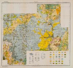
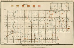
Reconnoissance [sic] Soil Survey of South Part of North Central Wisconsin
-
Soil Map: Wisconsin, Reconnoissance [sic] Survey - South Part of the North-Central Wisconsin Sheet
1918
Map: 20.5 in x 19.2 in, scale 1 in = 3 miles
-
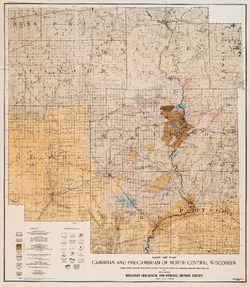
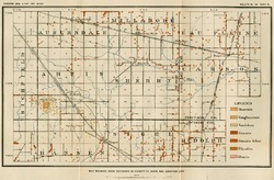
The Geology of North Central Wisconsin
-
Map of the Cambrian and Pre-Cambrian of North Central Wisconsin: Clark, Wood, Portage, Marathon, Lincoln, Taylor and Parts of Langlade, Rusk and Price Counties [plate 1]
1907
Map: 20.0 in x 22.9 in, scale 1 in = 3 miles
-
Map of the Pleistocene of North Central Wisconsin: Clark, Wood, Portage, Marathon, Lincoln, Taylor and Parts of Langlade, Rusk and Price Counties [plate 2]
1907
Map: 20.1 in x 23.1 in, scale 1 in = 3 miles
-
Map Showing Rock Outcrops in Vicinity of Athens and Upper Rib River [plate 8]
1907
Map: 13.6 in x 8.8 in
-
Map Showing Rock Outcrops in Vicinity of Arpin and Junction City [plate 12]
1907
Map: 15.1 in x 9.9 in
-
Map Showing Rock Outcrops in Vicinity of Hewitt and Rozellville [plate 15]
1907
Map: 10.9 in x 7.5 in

Publications Catalog
Wisconsin Geological and Natural History Survey