-
Bedrock Geology of Wisconsin, Northwest Sheet
Types of bedrock, formation names, major faults, and time period of formation.-
Bedrock Geology of Wisconsin, Northwest Sheet
1987
Map: 37.5 in x 22 in, scale 1:250,000; 35.5 in x 20 in
-
Bedrock Geology of Wisconsin, Northwest Sheet [GIS data]
1987
GIS Data: MrSID files (.sid file format)
-
-
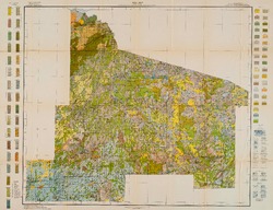
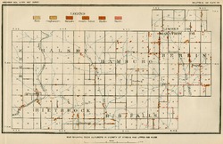
Reconnoissance [sic] Soil Survey of North Part of North Central Wisconsin
-
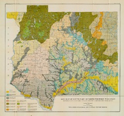
Soil Map: Wisconsin, Reconnoissance [sic] Survey - North Part of North Central Wisconsin Sheet
1916
Map: 26.0 in x 20.0 in, scale 1 in = 3 miles
-
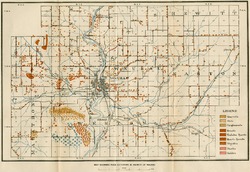
Mineral Land Classification, Showing Indications of Iron Formation in Parts of Ashland, Bayfield, Washburn, Sawyer, Price, Oneida, Forest, Rusk, Barron, and Chippewa Counties
-
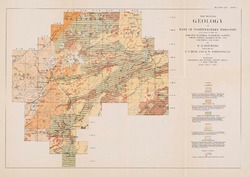
Map Showing Geology of Part of Northwestern Wisconsin Including Parts of Ashland, Bayfield, Washburn, Sawyer, Price, Oneida, Barron, Rusk, and Chippewa Counties [plate 1]
1915
Map: 20.7 in x 13.5 in, scale 1 in = 6 miles
-
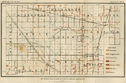
The Geology of North Central Wisconsin
-
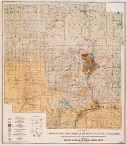
Map of the Cambrian and Pre-Cambrian of North Central Wisconsin: Clark, Wood, Portage, Marathon, Lincoln, Taylor and Parts of Langlade, Rusk and Price Counties [plate 1]
1907
Map: 20.0 in x 22.9 in, scale 1 in = 3 miles
-
Map of the Pleistocene of North Central Wisconsin: Clark, Wood, Portage, Marathon, Lincoln, Taylor and Parts of Langlade, Rusk and Price Counties [plate 2]
1907
Map: 20.1 in x 23.1 in, scale 1 in = 3 miles
-
Map Showing Rock Outcrops in Vicinity of Athens and Upper Rib River [plate 8]
1907
Map: 13.6 in x 8.8 in
-
Map Showing Rock Outcrops in Vicinity of Arpin and Junction City [plate 12]
1907
Map: 15.1 in x 9.9 in
-
Map Showing Rock Outcrops in Vicinity of Hewitt and Rozellville [plate 15]
1907
Map: 10.9 in x 7.5 in

Publications Catalog
Wisconsin Geological and Natural History Survey