-
Assessment of Virus Presence and Potential Virus Pathways in Deep Municipal Wells
Open-file report; contains unpublished data that has not yet been peer-reviewed. -
Investigating Groundwater Recharge to the Cambrian-Ordovician Aquifer through Fine-Grained Glacial Deposits in the Fox River Valley
Open-file report; contains unpublished data that has not yet been peer-reviewed. -
TILLPRO: A Database Containing Physical Properties of Unlithified Sediment Samples
TILLPRO is a Micosoft Access database of physical properties for unlithified sediment samples collected in Wisconsin. The data compiled in the database includes grain size, shear strength, preconsolidation stress, plasticity, and hydraulic conductivity.-
TILLPRO: A Database Containing Physical Properties of Unlithified Sediment Samples
2008
Database: Microsoft Access database (.mdb file format)
-
-
Delineation of Areas Contributing Groundwater to Springs and Wetlands Supporting the Hine's Emerald Dragonfly, Door County, Wisconsin
Open-file report; contains unpublished data that has not yet been peer-reviewed. -
Mechanisms of Groundwater Flow Across the Maquoketa Formation
Open-file report; contains unpublished data that has not yet been peer-reviewed. -
Groundwater Sustainability in a Humid Climate: Groundwater Pumping, Groundwater Consumption, and Land-Use Change
Open-file report; contains unpublished data that has not yet been peer-reviewed. -
Assessing the Ecological Status and Vulnerability of Springs in Wisconsin
Open-file report; contains unpublished data that has not yet been peer-reviewed.-
Assessing the Ecological Status and Vulnerability of Springs in Wisconsin [GIS Data]
2008
GIS Data: Shapefiles (.shp file format), images (.jpeg file format), Microsoft Access database (.mdb file format)
-
Hydrostratigraphy of West-Central Wisconsin: A New Approach to Groundwater Management
Open-file report; contains unpublished data that has not yet been peer-reviewed.-
Hydrostratigraphy of West-Central Wisconsin: A New Approach to Groundwater Management [data]
2008
Data: Documents (.pdf file format), data (.grf, .WCL, .ca2 and .AA1 file formats)
-
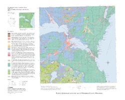
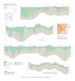
Quaternary Geology of Winnebago County, Wisconsin
-
Quaternary Geology of Winnebago County, Wisconsin (version 2) [GIS data]
2008
GIS Data: GeMS Level 3 file geodatabase (.gdb file format)
-
Quaternary Geologic Map of Winnebago County, Wisconsin [plate 1]
2008
Map: 25 in x 20 in, scale 1:100,000
-
Geologic Cross Sections of Winnebago County, Wisconsin [plate 2]
2008
Plate: 25 in x 27 in, scale 1:100,000

Publications Catalog
Wisconsin Geological and Natural History Survey