-
Depth to Silurian Bedrock in Eastern Wisconsin
Silurian-aged bedrock in eastern Wisconsin is shallow, fractured, and contains groundwater that is susceptible to surface water contamination. Revisions to Wisconsin state rules ATCP50 and NR151 to regulate manure spreading over this Silurian-aged bedrock create the need for a depth-to-bedrock map of eastern WI. The Wisconsin Geological and Natural...-
Depth to Silurian Bedrock in Eastern Wisconsin [dataset 1]
2025
GIS Data: File geodatabase (.gdb file format)
-
-
Wisconsin Groundwater-Level Monitoring Network Improvements, 2020-2022
This report documents work completed as part of a grant from the U.S. Geological Survey's National Groundwater Monitoring Network (NGWMN) program. It provides an overview of the Wisconsin Groundwater-Level Monitoring Network (WGLMN) and provides detailed description of well evaluation and repair activities, and drilling of new monitoring wells across the... -
Wisconsin Groundwater-Level Monitoring Network Improvement
The Wisconsin Groundwater-Level Monitoring Network consists of 93 wells and 2 spring gaging stations. This report documents work performed on seven of the wells between August 1, 2016 and July 31, 2017, and appendices provide historical reference documents. -
Mechanisms of Groundwater Flow Across the Maquoketa Formation
Open-file report; contains unpublished data that has not yet been peer-reviewed. -
Merging Pleistocene Lithostratigraphy with Geotechnical and Hydrogeologic Data--Examples from Eastern Wisconsin
Open-file report; contains unpublished data that has not yet been peer-reviewed. -
A Subsurface Study of the St. Peter Sandstone in Southern and Eastern Wisconsin
-
Structure Contour Map of the Pre-St. Peter Sandstone Erosion Surface in Southern and Eastern Wisconsin [plate 1]
1985
Map: 39.7 in x 23.5 in, scale 1:750,000
-
Paleogeologic Map of the Pre-St. Peter Sandstone Surface in Southern and Eastern Wisconsin & Thickness Map of the St. Peter Sandstone in Southern and Eastern Wisconsin [plate 2]
1985
Map: 39.4 in x 23.6 in, scale 1:750,000
-
Pleistocene Geology of Southern Wisconsin
Field trip guide with special papers by R.F. Black, N.K. Bleuer, F.D. Hole, N.P. Lasca, and L.J. Maher, Jr., 1970, 175 p. -
The Geography and Economic Development of Southeastern Wisconsin
-
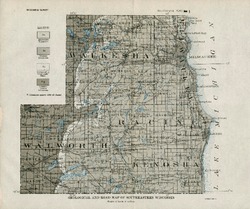
Geological and Road Map of Southeastern Wisconsin [plate 1]
1921
Map: 11.2 in x 9.4 in, scale 1 in = 6 miles

Publications Catalog
Wisconsin Geological and Natural History Survey