-
Sandstones of the Wisconsin Coast of Lake Superior
-
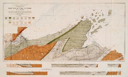
Geological Map of Part of West End of Lake Superior
1912
Map: 25.2 in x 15.2 in, scale 1 in = 3 miles
-
On the Lakes of Southeastern Wisconsin
-
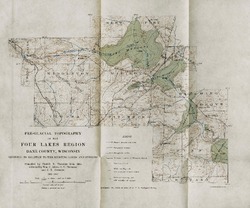
Pre-Glacial Topography of the Four Lakes Region, Dane County, Wisconsin: Showing Its Relation to the Existing Lakes and Streams [plate 37]
1910
Map: 11.6 in x 9.7 in, scale 1 in = 2 miles

Publications Catalog
Wisconsin Geological and Natural History Survey