-
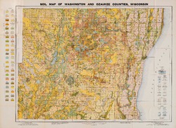
Quaternary Geology of Ozaukee and Washington Counties, Wisconsin
-
Quaternary Geology of Ozaukee and Washington Counties, Wisconsin (version 2) [GIS data]
1997
GIS Data: GeMS Level 3 file geodatabase (.gdb file format)
-
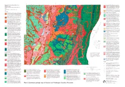
Quaternary Geologic Map of Ozaukee and Washington Counties, Wisconsin [plate 1]
1997
Map: 32.5 in x 22.5 in, scale 1:100,000
-
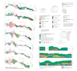
Geologic Cross Sections of Ozaukee and Washington Counties, Wisconsin [plate 2]
1997
Plate: 26 in x 24 in, scale 1:100,000
-
On the Lakes of Southeastern Wisconsin
-
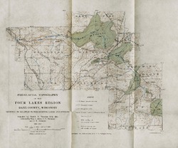
Pre-Glacial Topography of the Four Lakes Region, Dane County, Wisconsin: Showing Its Relation to the Existing Lakes and Streams [plate 37]
1910
Map: 11.6 in x 9.7 in, scale 1 in = 2 miles

Publications Catalog
Wisconsin Geological and Natural History Survey