-
A Subsurface Study of the St. Peter Sandstone in Southern and Eastern Wisconsin
-
Structure Contour Map of the Pre-St. Peter Sandstone Erosion Surface in Southern and Eastern Wisconsin [plate 1]
1985
Map: 39.7 in x 23.5 in, scale 1:750,000
-
Paleogeologic Map of the Pre-St. Peter Sandstone Surface in Southern and Eastern Wisconsin & Thickness Map of the St. Peter Sandstone in Southern and Eastern Wisconsin [plate 2]
1985
Map: 39.4 in x 23.6 in, scale 1:750,000
-
Ground-Water Resources and Geology of Columbia County, Wisconsin
-
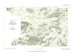
Water-Table Map of Columbia County, Wisconsin, 1974 [plate 1]
1978
Map: 24 in x 18 in, scale 1:24,000
-
Pleistocene Geology of Southern Wisconsin
Field trip guide with special papers by R.F. Black, N.K. Bleuer, F.D. Hole, N.P. Lasca, and L.J. Maher, Jr., 1970, 175 p. -
Geology of the Baraboo District, Wisconsin: A Description and Field Guide Incorporating Structural Analysis of the Precambrian Rocks and Sedimentologic Studies of the Paleozoic Strata
With summaries: Glacial Geology, R.F. Black; and Plant Ecology of the Baraboo Hills, J.H. Zimmerman.-
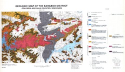
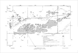
Geologic Map of the Baraboo District, Columbia and Sauk Counties, Wisconsin [plate 1]
1970
Map: 39.5 in x 22.7 in, scale 1:62,500
-
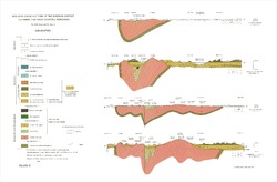
Geologic Cross Sections of the Baraboo District, Columbia and Sauk Counties, Wisconsin [plate 2]
1970
Plate: 32 in x 21 in
-
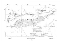
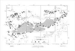
Map of Main Phase Minor Structures in the Baraboo Syncline, Columbia and Sauk Counties, Wisconsin [plate 3]
1970
Map: 31.5 in x 21.5 in
-
Structural Map of the Baraboo Syncline, Columbia and Sauk Counties, Wisconsin [plate 4]
1970
Map: 31.5 in x 21.5 in
-
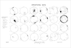
Structural Data: Lower Hemisphere Equal-Area Stereoplots of Structural Elements in the Baraboo Quartzite [plate 5]
1970
Plate: 31.5 in x 21.5 in
-
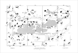
Orientations of Cross Stratification in Cambrian and Ordovician Sandstones [plate 7]
1970
Map: 31.5 in x 21.5 in

Publications Catalog
Wisconsin Geological and Natural History Survey