-
Hydrogeology and Simulation of Groundwater Flow in Columbia County, Wisconsin
The WGNHS and the U.S. Geological Survey characterized the hydrogeology and developed a groundwater flow model to assess groundwater resources in Columbia County. This report describes regionally extensive aquifers and presents several extensive datasets collected from deep wells across the county. The report also documents the construction and... -
Quaternary Geology of Columbia, Green Lake, and Marquette Counties, Wisconsin
Columbia, Green Lake, and Marquette Counties were glaciated during the last ice age, and large areas were inundated with water from proglacial lakes and large meltwater rivers that occupied the valleys of the existing Wisconsin and Fox Rivers. These processes resulted in rolling upland hills, including drumlins punctuated by low-lying areas dominated by...-
GIS Data for the Quaternary Geology of Columbia, Green Lake, and Marquette Counties, Wisconsin [dataset 1]
2021
GIS Data: GeMS Level 3 file geodatabase (.gdb file format), shapefiles (.shp file format), GeoPackage (.gpkg file format)
-
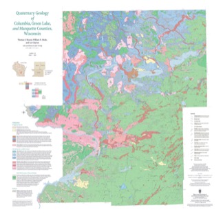
Quaternary Geology of Columbia, Green Lake, and Marquette Counties, Wisconsin [plate 1]
2021
Map: 35 in x 34 in, scale 1:100,000

Publications Catalog
Wisconsin Geological and Natural History Survey