-
Hydrogeology of the sandy uplands of the Bayfield Peninsula, Wisconsin
The sandy uplands of the Bayfield Peninsula are primary contributors to regional groundwater recharge and provide baseflow to streams in the area. Few data exist, however, to characterize upland hydrogeology or its susceptibility to groundwater contamination. Here, data from two new cores and wells, one existing well, and a lake in the sandy uplands...-
Rotosonic core data from the sandy uplands of the Bayfield Peninsula, Wisconsin [dataset 1]
2022
Data: Spreadsheets (.csv)
-
Water-level measurements from two monitoring wells in the sandy uplands of the Bayfield Peninsula, Wisconsin [dataset 2]
2022
Data: Spreadsheets (.csv)
-
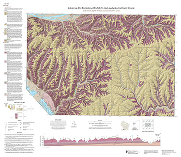
Geologic map of the Bloomington and Brodtville 7.5-minute quadrangles, Grant County, Wisconsin
The geologic map of the Bloomington and Brodtville quadrangles includes 1:24,000 scale mapping of both surficial and bedrock geology. There is little structural folding or faulting in this portion of the Driftless Area. Thus, it is ideal for studying the hydrostratigraphic framework of the mapped units. The accompanying report presents stratigraphic...-
Geologic map of the Bloomington and Brodtville 7.5-minute quadrangles, Grant County, Wisconsin
2022
Map: 41 in x 35 in, scale 1:24,000
-
GIS data for the geologic map of the Bloomington and Brodtville 7.5-minute quadrangles, Grant County, Wisconsin [dataset 1]
2022
GIS Data: File geodatabase
-
-
Wisconsin Groundwater-Level Monitoring Network Improvements, 2018-2021
This report documents work completed as part of a grant from the U.S. Geological Survey’s National Groundwater Monitoring Network (NGWMN) program. It provides an overview of the Wisconsin Groundwater-Level Monitoring Network (WGLMN) and provides detailed description of well evaluation and repair activities, and drilling of new monitoring wells across the... -
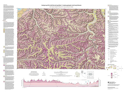
Geologic map of the Castle Rock and Long Hollow 7.5-minute quadrangles, Grant County, Wisconsin
The geologic map of the Castle Rock and Long Hollow quadrangles includes 1:24,000 scale mapping of both surficial and bedrock geology. The accompanying report presents new observations about bedrock folds and fracture sets in this portion of the Driftless Area that lies just north of the main Upper Mississippi Valley zinc-lead mineral district. The...-
Geologic map of the Castle Rock and Long Hollow 7.5-minute quadrangles, Grant County, Wisconsin (revised 2022)
2022
Map: 48 in x 36 in, scale 1:24,000
-
GIS data for the geologic map of the Castle Rock and Long Hollow 7.5-minute quadrangles, Grant County, Wisconsin [dataset 1]
2022
GIS Data: File geodatabase
-

Publications Catalog
Wisconsin Geological and Natural History Survey