-
Quaternary Geology of Oneida County, Wisconsin
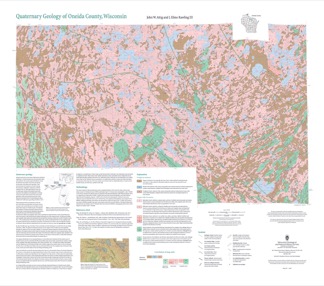
Oneida County, in northern Wisconsin, is a mostly forested area dotted with lakes and wetlands. The watery landscape is a legacy of a time when glaciers flowed across the area. Geologists Attig and Rawling mapped the Quaternary geology of the county, documenting where the glaciers paused, the sediments that were deposited, and the landforms that were...-
Quaternary Geology of Oneida County, Wisconsin (version 2) [GIS data]
2020
GIS Data: GeMS Level 3 file geodatabase (.gdb file format), shapefiles (.shp file format), GeoPackage (.gpkg file format)
-
Geology of Wisconsin - Outcrop Descriptions
These descriptions illustrate various geologic formations, features, and characteristics. Individual descriptions are one to ten pages long, and include a map with specific location, a description of geologic features, and a discussion of the geologic significance.-
Adams County: Upper Wisconsin Dells (T14N R6E Sec28)
Report: 3 p.
-
Adams County: Friendship Mound (T17N R6E Sec5)
Report: 2 p.
-
Adams County: Hamilton Mound (T20N R6E Sec36)
Report: 4 p.
-
Ashland County: Mt. Whittelsey (T44N R2W Sec9A)
Report: 3 p.
-
Ashland County: Mellen Gabbro (T45N R2W Sec30)
Report: 3 p.
-
Ashland County: Mellen Granite (T45N R2W Sec31)
Report: 3 p.
-
Ashland County: White River (T46N R4W Sec6)
Report: 2 p.
-
Bayfield County: South Fish Creek (T47N R5W Sec20)
Report: 2 p.
- 123 more...
-
-
Geoscience Wisconsin Volume 12
-
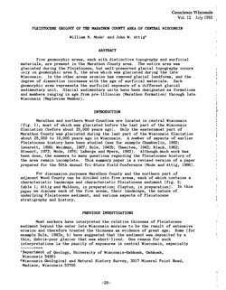
Subsurface Stratigraphic Relationships of the Upper Silurian and Devonian Rock of Milwaukee County, Wisconsin
1988
Journal Article: p. 1-23
-
Petrochemistry of Precambrian Granitic Rock from Northeastern Wisconsin
1988
Journal Article: p. 45-61
-
Seismic Refraction Measurements in Bedrock of the Trout Lake Region of Vilas County, Northern Wisconsin
1988
Journal Article: p. 63-76
-
Seasonal Geochemistry of Two Tufa-Depositing Springs in Southwestern Wisconsin
1988
Journal Article: p. 77-83

Publications Catalog
Wisconsin Geological and Natural History Survey