-
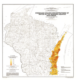
Dissolved-Solids Concentrations of Water in the Niagara Aquifer, Wisconsin
-
Dissolved-Solids Concentrations of Water in the Niagara Aquifer, Wisconsin
1975
Map: 23 in x 24 in, scale 1:1,000,000
-
-
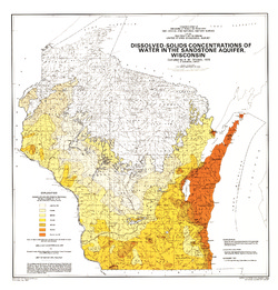
Dissolved-Solids Concentrations of Water in the Sandstone Aquifer, Wisconsin
-
Dissolved-Solids Concentrations of Water in the Sandstone Aquifer, Wisconsin
1975
Map: 23 in x 24 in, scale 1:1,000,000
-
-
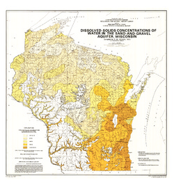
Dissolved-Solids Concentrations of Water in the Sand-and-Gravel Aquifer, Wisconsin
-
Dissolved-Solids Concentrations of Water in the Sand-and-Gravel Aquifer, Wisconsin
1975
Map: 23 in x 24.5 in, scale 1:1,000,000
-
-
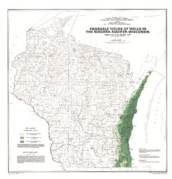
Probable Yields of Wells in the Niagara Aquifer, Wisconsin
-
Probable Yields of Wells in the Niagara Aquifer, Wisconsin
1975
Map: 23 in x 24 in, scale 1:1,000,000
-
-
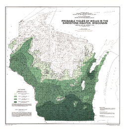
Probable Yields of Wells in the Sandstone Aquifer, Wisconsin
-
Probable Yields of Wells in the Sandstone Aquifer, Wisconsin
1975
Map: 23 in x 24 in, scale 1:1,000,000
-
-
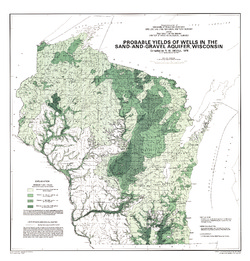
Probable Yields of Wells in the Sand-and-Gravel Aquifer, Wisconsin
-
Probable Yields of Wells in the Sand-and-Gravel Aquifer, Wisconsin
1975
Map: 23 in x 24 in, scale 1:1,000,000
-
-
Wisconsin Lakes Levels--Their Ups and Downs
This booklet examines lake-level fluctuations by lake type for 28 Wisconsin lakes. Records span a period of 20 years or longer.

Publications Catalog
Wisconsin Geological and Natural History Survey