-
Hydrogeology of the sandy uplands of the Bayfield Peninsula, Wisconsin
The sandy uplands of the Bayfield Peninsula are primary contributors to regional groundwater recharge and provide baseflow to streams in the area. Few data exist, however, to characterize upland hydrogeology or its susceptibility to groundwater contamination. Here, data from two new cores and wells, one existing well, and a lake in the sandy uplands...-
Rotosonic core data from the sandy uplands of the Bayfield Peninsula, Wisconsin [dataset 1]
2022
Data: Spreadsheets (.csv file format)
-
Water-level measurements from two monitoring wells in the sandy uplands of the Bayfield Peninsula, Wisconsin [dataset 2]
2022
Data: Spreadsheets (.csv file format)
-
Bayfield County [Wisconsin] Water-Table Map and Water Well Database
This report provides information about well construction, groundwater flow, and resulting implications for well susceptibility in Bayfield County, Wisconsin. The work follows an earlier groundwater study that focused on two agricultural areas within Bayfield County.-
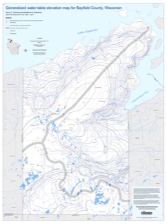
Generalized Water-Table Elevation Map for Bayfield County, Wisconsin [GIS data]
2017
GIS Data: Shapefiles (.shp file format)
-
Generalized Water-Table Elevation Map for Bayfield County, Wisconsin [plate 1]
2017
Plate: 30 in x 40 in, scale 1:100,000

Publications Catalog
Wisconsin Geological and Natural History Survey