-
Chequamegon-Nicolet National Forest Water Quality Database
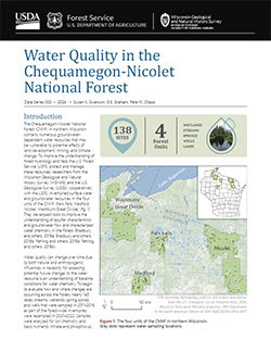
The Chequamegon-Nicolet National Forest (CNNF) in northern Wisconsin contains numerous groundwater-dependent water resources that may be vulnerable to potential effects of land development, mining, and climate change. In order to monitor water quality over time, 138 of the lakes, streams, wetlands, spring ponds, springs, and wells were sampled in...-
Chequamegon-Nicolet National Forest Water Quality Database
2024
Data: Spreadsheets (.csv file format)
-
-
Inventory and Analysis of Flowing Artesian Wells in Bayfield County, Wisconsin
This report presents a county-wide inventory of flowing artesian wells in Bayfield County. Flowing artesian wells are a remarkable resource of high-quality water that both community members and tourists value. This report provides baseline water quality data that are a valuable resource for future assessments. Data collection occurred in 2022. Includes...-
Photos of Flowing Artesian Wells [dataset 2]
2024
Data: Spreadsheets (.csv file format), images (.jpg file format)
-
Hydrogeology of the sandy uplands of the Bayfield Peninsula, Wisconsin
The sandy uplands of the Bayfield Peninsula are primary contributors to regional groundwater recharge and provide baseflow to streams in the area. Few data exist, however, to characterize upland hydrogeology or its susceptibility to groundwater contamination. Here, data from two new cores and wells, one existing well, and a lake in the sandy uplands...-
Rotosonic core data from the sandy uplands of the Bayfield Peninsula, Wisconsin [dataset 1]
2022
Data: Spreadsheets (.csv file format)
-
Water-level measurements from two monitoring wells in the sandy uplands of the Bayfield Peninsula, Wisconsin [dataset 2]
2022
Data: Spreadsheets (.csv file format)
-
Hydrogeologic Atlas of Bayfield County, Wisconsin
Analysis of the groundwater resources in Bayfield County, Wisconsin. Includes report, five plates, and digital data.-
Hydrogeologic Atlas of Bayfield County, Wisconsin [appendices]
2019
Data: Documents (.pdf file format)
-
Hydrogeologic Atlas of Bayfield County, Wisconsin [GIS data]
2019
GIS Data: File geodatabase (.gdb file format)
-
Generalized Water-Table Elevation Map of Bayfield County, Wisconsin [plate 1]
2019
Plate: 29.5 in x 39.5 in, scale 1:100,000
-
Depth to Water Table Map of Bayfield County, Wisconsin [plate 2]
2019
Plate: 29.5 in x 39.5 in, scale 1:100,000
-
Depth to Bedrock Map of Bayfield County, Wisconsin [plate 3]
2019
Plate: 29.5 in x 39.5 in, scale 1:100,000
-
Groundwater Recharge Map of Bayfield County, Wisconsin [plate 4]
2019
Plate: 29.5 in x 39.5 in, scale 1:100,000
-
Groundwater Susceptibility Map of Bayfield County, Wisconsin [plate 5]
2019
Plate: 29.5 in x 39.5 in, scale 1:100,000

Publications Catalog
Wisconsin Geological and Natural History Survey