-
Evaluation of Groundwater Flow Models Used to Simulate the Effects of Proposed Mining on the Groundwater-Surface Water System in the Vicinity of Crandon, Forest County, Wisconsin
Open-file report; contains unpublished data that has not yet been peer-reviewed. -
Groundwater Quality Investigation Maps of Pepin County, Wisconsin
Includes Plate 1: Nitrate as Nitrogen in mg/L. Plate 2: Chloride in mg/L. Plate 3: Laboratory Measurement of Alkalinity in mg/L. Plate 4: Total Hardness in mg/L. Plate 5: Laboratory Measurement of Electrical Conductivity in μmhos/cm. Plate 6: Ferrous Iron in mg/L.-
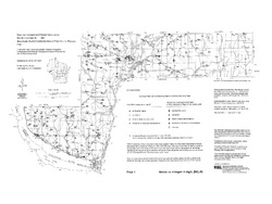
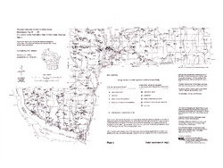
Groundwater Quality Investigation Maps of Pepin County, Wisconsin: Nitrate as Nitrogen in mg/L [plate 1]
1994
Map: 24 in x 18 in, scale 1:100,000
-
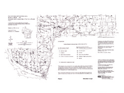
Groundwater Quality Investigation Maps of Pepin County, Wisconsin: Chloride in mg/L [plate 2]
1994
Map: 24 in x 18 in, scale 1:100,000
-
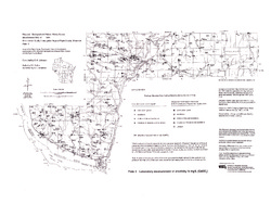
Groundwater Quality Investigation Maps of Pepin County, Wisconsin: Laboratory Measurement of Alkalinity in mg/L [plate 3]
1994
Map: 24 in x 18 in, scale 1:100,000
-
Groundwater Quality Investigation Maps of Pepin County, Wisconsin: Total Hardness in mg/L [plate 4]
1994
Map: 24 in x 18 in, scale 1:100,000
-
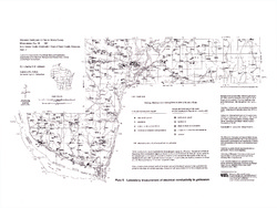
Groundwater Quality Investigation Maps of Pepin County, Wisconsin: Laboratory Measurement of Electrical Conductivity in ?mhos/cm [plate 5]
1994
Map: 24 in x 18 in, scale 1:100,000
-
Groundwater Quality Investigation Maps of Pepin County, Wisconsin: Ferrous Iron in mg/L [plate 6]
1994
Map: 23.7 in x 17.6 in, scale 1:100,000
-
-
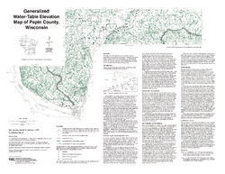
Generalized Water-Table Elevation of Pepin County, Wisconsin
-
Generalized Water-Table Elevation Map of Pepin County, Wisconsin
1993
Map: 25 in x 19.3 in, scale 1:100,000
-

Publications Catalog
Wisconsin Geological and Natural History Survey