-
Quaternary Geology of Waupaca County, Wisconsin
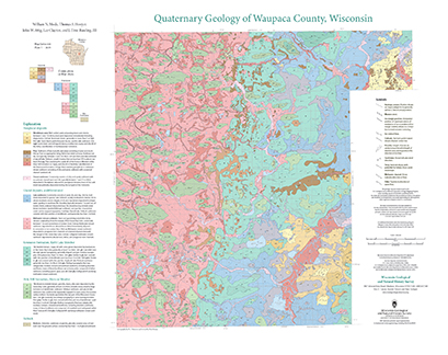
The Quaternary geologic map of Waupaca County, Wisconsin, provides details about the surficial sediment and landscapes that were formed underneath and adjacent to the Laurentide Ice Sheet during the late Wisconsin Glaciation (ca. 20,000 years before present). These landscapes include lowlands underlain by glacial and postglacial lake sediment, uplands...-
Geologic Log Data for Quaternary Geology of Waupaca County, Wisconsin [dataset 1]
2023
Data: Spreadsheets (.xlsx file format)
-
GIS Data for Quaternary Geology of Waupaca County, Wisconsin [dataset 2]
2023
GIS Data: GeMS Level 3 file geodatabase (.gdb file format), shapefiles (.shp file format), GeoPackage (.gpkg file format)
-
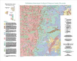
Preliminary Quaternary Geology of Waupaca County, Wisconsin
This open-file report contains a map (PDF) and GIS data (shapefiles) of the glacial and post-glacial deposits of Waupaca County in central Wisconsin. This map and GIS data were superseded by a Map Series publication in 2023: https://doi.org/10.54915/bger3320.-
Preliminary Quaternary Geology of Waupaca County, Wisconsin [plate 1]
2015
Map: 29 in x 23 in, scale 1:100,000
-
Preliminary Quaternary Geology of Waupaca County, Wisconsin [GIS data]
2015
GIS Data: Shapefiles (.shp file format)
-

Publications Catalog
Wisconsin Geological and Natural History Survey