-
Application of a Discrete Fracture Flow Model for Wellhead Protection at Sturgeon Bay, Wisconsin
Open-file report; contains unpublished data that has not yet been peer-reviewed. -
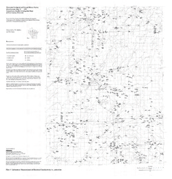
Groundwater Quality Investigation Maps of Buffalo County, Wisconsin
Includes Plate 1: Nitrate as Nitrogen in mg/L. Plate 2: Chloride in mg/L. Plate 3: Laboratory Measurement of Alkalinity in mg/L. Plate 4: Total Hardness in mg/L. Plate 5: Laboratory Measurement of Electrical Conductivity in μmhos/cm. Plate 6: Ferrous Iron in mg/L.-
Groundwater Quality Investigation Maps of Buffalo County, Wisconsin: Nitrate as Nitrogen in mg/L [plate 1]
2001
Map: 20 in x 30 in, scale 1:100,000
-
Groundwater Quality Investigation Maps of Buffalo County, Wisconsin: Chloride in mg/L [plate 2]
2001
Map: 20 in x 30 in, scale 1:100,000
-
Groundwater Quality Investigation Maps of Buffalo County, Wisconsin: Laboratory Measurement of Alkalinity in mg/L [plate 3]
2001
Map: 20 in x 30 in, scale 1:100,000
-
Groundwater Quality Investigation Maps of Buffalo County, Wisconsin: Total Hardness in mg/L [plate 4]
2001
Map: 19.7 in x 27.7 in, scale 1:100,000
-
Groundwater Quality Investigation Maps of Buffalo County, Wisconsin: Laboratory Measurement of Electrical Conductivity in ?mhos/cm [plate 5]
2001
Map: 21 in x 30 in, scale 1:100,000
-
Groundwater Quality Investigation Maps of Buffalo County, Wisconsin: Ferrous Iron in mg/L [plate 6]
2001
Map: 20 in x 30 in, scale 1:100,000
-
-
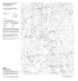
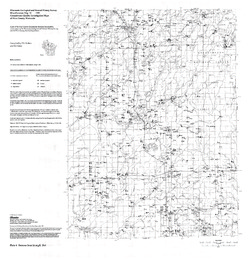
Groundwater Quality Investigation Maps of Price County, Wisconsin
Includes Plate 1: Nitrate as Nitrogen in mg/L. Plate 2: Chloride in mg/L. Plate 3: Laboratory Measurement of Alkalinity in mg/L. Plate 4: Total Hardness in mg/L. Plate 5: Laboratory Measurement of Electrical Conductivity in μmhos/cm. Plate 6: Ferrous Iron in mg/L.-
Groundwater Quality Investigation Maps of Price County, Wisconsin: Nitrate as Nitrogen in mg/L [plate 1]
1999
Map: 29 in x 30 in, scale 1:100,000
-
Groundwater Quality Investigation Maps of Price County, Wisconsin: Chloride in mg/L [plate 2]
1999
Map: 29 in x 30 in, scale 1:100,000
-
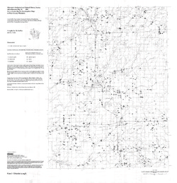
Groundwater Quality Investigation Maps of Price County, Wisconsin: Laboratory Measurement of Alkalinity in mg/L [plate 3]
1999
Map: 29 in x 30 in, scale 1:100,000
-
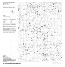
Groundwater Quality Investigation Maps of Price County, Wisconsin: Total Hardness in mg/L [plate 4]
1999
Map: 28.7 in x 30 in, scale 1:100,000
-
Groundwater Quality Investigation Maps of Price County, Wisconsin: Laboratory Measurement of Electrical Conductivity in ?mhos/cm [plate 5]
1999
Map: 28.9 in x 30 in, scale 1:100,000
-
Groundwater Quality Investigation Maps of Price County, Wisconsin: Ferrous Iron in mg/L [plate 6]
1999
Map: 29 in x 30 in, scale 1:100,000
-

Publications Catalog
Wisconsin Geological and Natural History Survey