-
Geology of the Baraboo Hills, Sauk and Columbia Counties, Wisconsin
Located in the south-central portion of the state, new geologic mapping of the frequently-visited Baraboo Hills has resulted in a revision of the stratigraphy of the Precambrian-aged bedrock. The Baraboo Quartzite is now divided into four informal members, and the maximum depositional age for the Baraboo Quartzite is 1714±17 million years old. These...-
Geology of the Baraboo Hills, Sauk and Columbia Counties, Wisconsin [plate 1]
2025
Map: 48.25 in x 29.25 in, scale 1:50,000
-
GIS Data for Geology of the Baraboo Hills, Sauk and Columbia Counties, Wisconsin [dataset 1]
2025
GIS Data: GeMS Level 3 file geodatabase (.gdb file format) and GeoPackage (.gpkg file fomat)
-
Geologic Map of the Durwards Glen 7.5-Minute Quadrangle, Columbia and Sauk Counties, Wisconsin
The Durwards Glen 7.5-minute quadrangle map is located in Columbia and Sauk counties, southeast of the city of Baraboo. This geologic map includes Precambrian through Quaternary units. New mapping has focused on subdividing the Baraboo Quartzite into four separate members and delineating Quaternary deposits in greater detail than prior work.-
Geologic Map of the Durwards Glen 7.5-Minute Quadrangle, Columbia and Sauk Counties, Wisconsin
2024
Map: 35 x 40 in, scale 1:24,000
-
GIS Data for the Geologic Map of the Durwards Glen 7.5-Minute Quadrangle, Columbia and Sauk Counties, Wisconsin [dataset 1]
2024
GIS Data: GeMS Level 3 file geodatabase (.gdb file format), shapefiles (.shp file format), GeoPackage (.gpkg file format)
-
-
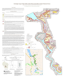
Geologic Map of the Dells of the Wisconsin River State Natural Area
The geologic map of the Dells of the Wisconsin River State Natural Area provides a detailed look at the bedrock geology present at one of Wisconsin's most cherished natural sites. The map and accompanying report present the Paleozoic bedrock stratigraphy of the visible formations, as well as an interpretation of their depositional environment. This map...-
Geologic Map of the Dells of the Wisconsin River State Natural Area
2023
Map: 30 x 36 in, scale 1:12,000
-

Publications Catalog
Wisconsin Geological and Natural History Survey