-
Elevation contours of the Precambrian surface of south-central Wisconsin
Elevation contour data and an accompanying report provide an updated interpretation of the elevation of the top of Precambrian bedrock in south-central Wisconsin. The elevation surface was developed from geologic and geophysical data, and provides new detail on the entrenched bedrock valleys that were incised into the north and south ranges of the Baraboo...-
Elevation contours of the Precambrian surface of south-central Wisconsin [dataset 1]
2022
GIS Data: File geodatabase (.gdb file format)
-
-
Hydrogeology of Fort McCoy Geothermal Test Well 5
Test hole drilled to 1,000 feet on Fort McCoy property provides data for understanding the geothermal gradient in Wisconsin and the hydrogeologic conditions found at Fort McCoy.-
Hydrogeology of Fort McCoy Geothermal Test Well 5 [appendices]
2016
Data: Documents (.pdf file format), spreadsheets (.xlsx file format)
-
Middle Keweenawan Basin Evolution Inferred from Geophysical Analysis of Strongly Magnetic Intrusion, Clam Lake, Wisconsin
Open-file report; contains unpublished data that has not yet been peer-reviewed. -
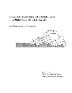
Regional-Scale Geologic Interpretation of Seismic Reflection, Gravity and Magnetic Profiles Collected along the Western Arm of the Midcontinent Rift System, Upper Peninsula of Michigan, Wisconsin, Minnesota and Iowa
Open-file report; contains unpublished data that has not yet been peer-reviewed.-
Regional-Scale Geologic Interpretation of Seismic Reflection, Gravity, and Magnetic Profiles Collected Along the Western Arm of the Midcontinent Rift System, Upper Peninsula of Michigan, Wisconsin, Minnesota and Iowa
2002
Report: HTML interactive document (.html file format)
-
-
Principal Facts for Gravity Stations in the Wisconsin East-Central 1° by 2° Map Sheet
Open-file report; contains unpublished data that has not yet been peer-reviewed.-
Principal Facts for Gravity Stations in the Wisconsin East-Central 1° by 2° Map Sheet
1996
Data: Plain text files (.txt file format)
-
-
Principal Facts for Gravity Stations in the Wisconsin East/Central (Green Bay) 1° by 2° Map Sheet
Open-file report; contains unpublished data that has not yet been peer-reviewed.-
Principal Facts for Gravity Stations in the Wisconsin East-Central (Green Bay) 1° by 2° Map Sheet
1994
Data: Plain text files (.txt file format)
-
-
Principal Facts for Gravity Stations in the Wisconsin West-Central 1° by 2° Map Sheet
Open-file report; contains unpublished data that has not yet been peer-reviewed.-
Principal Facts for Gravity Stations in the Wisconsin West-Central 1° by 2° Map Sheet
1993
Data: Plain text files (.txt file format)
-
-
Gridded Aeromagnetic Data for Northern Wisconsin
Open-file report; contains unpublished data that has not yet been peer-reviewed. -
Principal Facts for Gravity Stations in the Wisconsin Superior 1° by 2° Map Sheet
Open-file report; contains unpublished data that has not yet been peer-reviewed.-
Principal Facts for Gravity Stations in the Wisconsin Superior 1° by 2° Map Sheet
1991
Data: Plain text files (.txt file format)
-
-
List of Earthquakes in Wisconsin
Open-file report; contains unpublished data that has not yet been peer-reviewed. -
List of WGNHS Geophysical Logs
Open-file report; contains unpublished data that has not yet been peer-reviewed. -
Analysis of Clam Lake Gravity and Magnetic Anomalies
Open-file report; contains unpublished data that has not yet been peer-reviewed. -
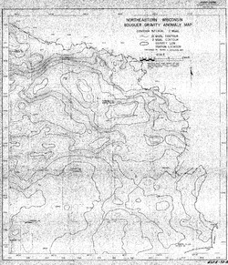
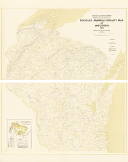
Bouguer Gravity Anomaly Map of Northeastern Wisconsin
Open-file report; contains unpublished data that has not yet been peer-reviewed. -
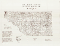
Simple Bouguer Anomaly Gravity Map, West Central Wisconsin Sheet
-
Simple Bouguer Gravity Map, West-Central Wisconsin Sheet
1993
Map: 43.3 in x 33.2 in, scale 1:250,000
-
-
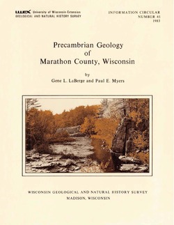
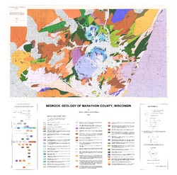
Precambrian Geology of Marathon County, Wisconsin
-
GIS Data for the Precambrian Geology of Marathon County, Wisconsin (version 2) [dataset 1]
1983
GIS Data: GeMS Level 3 file geodatabase (.gdb file format), shapefiles (.shp file format), GeoPackage (.gpkg file format)

Publications Catalog
Wisconsin Geological and Natural History Survey