-
Original Vegetation Cover of Wisconsin
Based on the original land-survey records compiled between 1832 and 1866. Also available as set with Wisconsin Land Cover map. -
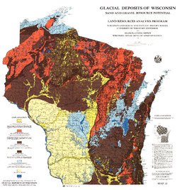
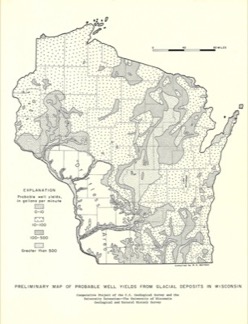
Glacial Deposits of Wisconsin: Sand and Gravel Resource Potential
Color map showing outwash, ground moraine, end moraine, and glacial deposits.-
Glacial Deposits of Wisconsin: Sand and Gravel Resource Potential
1976
Map: 45 in x 43.25 in, scale 1:500,000
-
-
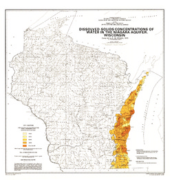
Dissolved-Solids Concentrations of Water in the Niagara Aquifer, Wisconsin
-
Dissolved-Solids Concentrations of Water in the Niagara Aquifer, Wisconsin
1975
Map: 23 in x 24 in, scale 1:1,000,000
-
-
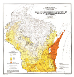
Dissolved-Solids Concentrations of Water in the Sandstone Aquifer, Wisconsin
-
Dissolved-Solids Concentrations of Water in the Sandstone Aquifer, Wisconsin
1975
Map: 23 in x 24 in, scale 1:1,000,000
-
-
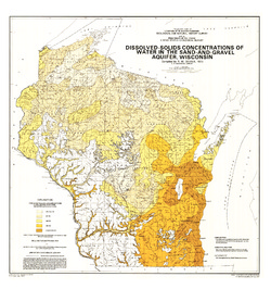
Dissolved-Solids Concentrations of Water in the Sand-and-Gravel Aquifer, Wisconsin
-
Dissolved-Solids Concentrations of Water in the Sand-and-Gravel Aquifer, Wisconsin
1975
Map: 23 in x 24.5 in, scale 1:1,000,000
-
-
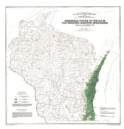
Probable Yields of Wells in the Niagara Aquifer, Wisconsin
-
Probable Yields of Wells in the Niagara Aquifer, Wisconsin
1975
Map: 23 in x 24 in, scale 1:1,000,000
-
-
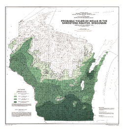
Probable Yields of Wells in the Sandstone Aquifer, Wisconsin
-
Probable Yields of Wells in the Sandstone Aquifer, Wisconsin
1975
Map: 23 in x 24 in, scale 1:1,000,000
-
-
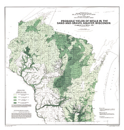
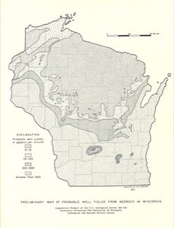
Probable Yields of Wells in the Sand-and-Gravel Aquifer, Wisconsin
-
Probable Yields of Wells in the Sand-and-Gravel Aquifer, Wisconsin
1975
Map: 23 in x 24 in, scale 1:1,000,000
-
-
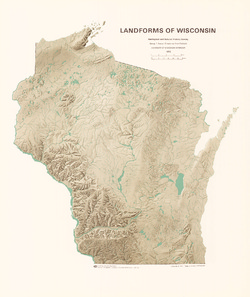
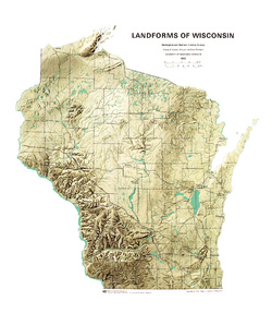
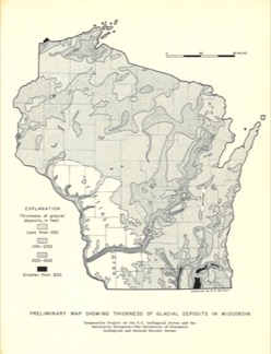
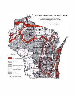
Ice Age Deposits of Wisconsin
Details the major glacial landforms of Wisconsin. Identifies where and what kind of rocks and soil debris were deposited in Wisconsin during the Ice Age.

Publications Catalog
Wisconsin Geological and Natural History Survey