-
Wisconsin Groundwater-Level Monitoring Network Improvements, 2018-2021
This report documents work completed as part of a grant from the U.S. Geological Survey’s National Groundwater Monitoring Network (NGWMN) program. It provides an overview of the Wisconsin Groundwater-Level Monitoring Network (WGLMN) and provides detailed description of well evaluation and repair activities, and drilling of new monitoring wells across the... -
Geochemistry and Mineralogy of the Wonewoc-Tunnel City Contact Interval Strata in Western Wisconsin
Results of regional study characterizing the elemental composition of rocks found at the Wonewoc-Tunnel City contact interval in west-central and southwest Wisconsin.-
Geochemistry and Mineralogy of the Wonewoc-Tunnel City Contact Interval Strata in Western Wisconsin [appendices]
2019
Data: Documents (.pdf file format), spreadsheets (.xlsx file format)
-
Groundwater Flow Model for Western Chippewa County
This report documents the groundwater flow model that was developed for western Chippewa County, Wisconsin. It also presents analyses that were run to evaluate how industrial sand (frac sand) mining and irrigated agriculture--might affect the water table and base flows of nearby headwater streams.-
Groundwater Flow Model for Western Chippewa County, Wisconsin, Including Analysis of Water Resources Related to Industrial Sand Mining and Irrigated Agriculture [appendices]
2019
Data: Spreadsheets (.xlsx file format), documents (.pdf file format)
-
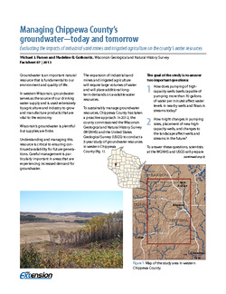
Managing Chippewa County's Groundwater--Today and Tomorrow: Evaluating the Impacts of Industrial Sand Mines and Irrigated Agriculture on the County's Water Resources
In 2012, Chippewa County commissioned the Wisconsin Geological Survey and the U.S. Geological Survey to conduct a 5-year study of the groundwater resources in the western part of the county. This 4-page publication describes the study and the computer models being developed for it. -
Executive Summary of the Chippewa County Groundwater Resource Investigation
Open-file report; contains unpublished data that has not yet been peer-reviewed. -
Discussion of the Phenomena of Local Glaciation in the Driftless Region
Open-file report; contains unpublished data that has not yet been peer-reviewed. -
Studies in the Driftless Region of Wisconsin
Open-file report; contains unpublished data that has not yet been peer-reviewed. -
Geology of Wisconsin - Outcrop Descriptions
These descriptions illustrate various geologic formations, features, and characteristics. Individual descriptions are one to ten pages long, and include a map with specific location, a description of geologic features, and a discussion of the geologic significance.-
Adams County: Upper Wisconsin Dells (T14N R6E Sec28)
Report: 3 p.
-
Adams County: Friendship Mound (T17N R6E Sec5)
Report: 2 p.
-
Adams County: Hamilton Mound (T20N R6E Sec36)
Report: 4 p.
-
Ashland County: Mt. Whittelsey (T44N R2W Sec9A)
Report: 3 p.
-
Ashland County: Mellen Gabbro (T45N R2W Sec30)
Report: 3 p.
-
Ashland County: Mellen Granite (T45N R2W Sec31)
Report: 3 p.
-
Ashland County: White River (T46N R4W Sec6)
Report: 2 p.
-
Bayfield County: South Fish Creek (T47N R5W Sec20)
Report: 2 p.
- 123 more...
-
-
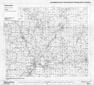
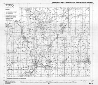
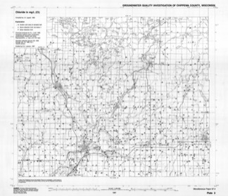
Groundwater Quality Investigation of Chippewa County, Wisconsin
Includes Plate 1: Sample Numbers. Plate 2: Nitrate–Nitrogen in mg/L. Plate 3: Chloride in mg/L. Plate 4: Laboratory Measurement of pH. Plate 5: Total Hardness in mg/L. Plate 6: Conductivity in µmhos/cm. Plate 7: Ferrous iron in mg/L.-
Groundwater Quality Investigation of Chippewa County, Wisconsin: Sample Numbers [plate 1]
1987
Map: 25.9 in x 23.3 in, scale 1:100,000
-
Groundwater Quality Investigation of Chippewa County, Wisconsin: Nitrate-Nitrogen in mg/L [plate 2]
1987
Map: 26.7 in x 23.3 in, scale 1:100,000
-
Groundwater Quality Investigation of Chippewa County, Wisconsin: Chloride in mg/L [plate 3]
1987
Map: 27 in x 23.3 in, scale 1:100,000
-
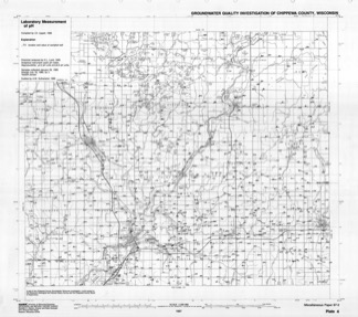
Groundwater Quality Investigation of Chippewa County, Wisconsin: Laboratory Measurement of pH [plate 4]
1987
Map: 26.7 in x 23.7 in, scale 1:100,000
-
Groundwater Quality Investigation of Chippewa County, Wisconsin: Total Hardness in mg/L [plate 5]
1987
Map: 26.9 in x 23.4 in, scale 1:100,000
-
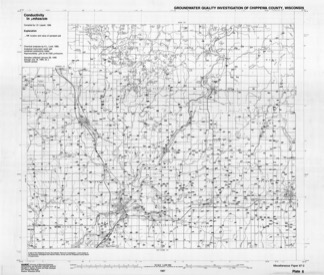
Groundwater Quality Investigation of Chippewa County, Wisconsin: Conductivity in ?mhos/cm [plate 6]
1987
Map: 27.4 in x 23.3 in, scale 1:100,000
-
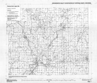
Groundwater Quality Investigation of Chippewa County, Wisconsin: Ferrous Iron in mg/L [plate 7]
1987
Map: 27.4 in x 23.6 in, scale 1:100,000
-
-
Bedrock Geology of Wisconsin, West-Central Sheet
Types of bedrock, formation names, major faults, and time period of formation.-
Bedrock Geology of Wisconsin, West-Central Sheet [GIS data]
1988
GIS Data: GeMS file geodatabase (.gdb file format)
-
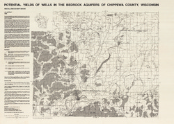
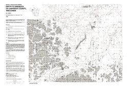
Potential Yields of Wells in the Bedrock Aquifers of Chippewa County, Wisconsin
-
Potential Yields of Wells in the Bedrock Aquifers of Chippewa County, Wisconsin
1988
Map: 31.5 in x 22.5 in, scale 1:100,000
-
-
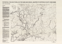
Potential Yields of Wells in the Sand and Gravel Aquifer of Chippewa County, Wisconsin
-
Potential Yields of Wells in the Sand-and-Gravel Aquifer of Chippewa County, Wisconsin
1988
Map: 31 in x 22.5 in, scale 1:100,000
-
-
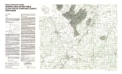
Generalized Water-Table Elevation of Chippewa County, Wisconsin
-
Generalized Water-Table Elevation of Chippewa County, Wisconsin
1988
Map: 36 in x 22 in, scale 1:100,000
-
GIS Data for the Generalized Water-Table Elevation of Chippewa County, Wisconsin [dataset 1]
1988
GIS Data: File geodatabase (.gdb file format)
-
-
Bedrock Geology of Wisconsin, Northwest Sheet
Types of bedrock, formation names, major faults, and time period of formation.-
Bedrock Geology of Wisconsin, Northwest Sheet
1987
Map: 37.5 in x 22 in, scale 1:250,000; 35.5 in x 20 in
-
Bedrock Geology of Wisconsin, Northwest Sheet [GIS data]
1987
GIS Data: MrSID files (.sid file format)
-
-
Field Trip Guidebook for Cambrian-Ordovician Geology of Western Wisconsin
With special papers: Lithologic Cycles in Lower Paleozoic Rocks of Western Wisconsin, M.E. Ostrom; and Lithostratigraphy of the Prairie du Chien Group, R.A. Davis, Jr. -
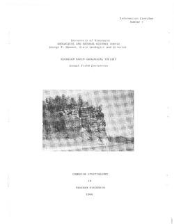
Cambrian Stratigraphy in Western Wisconsin
Notes accompanying a 1966 conference field trip covering geology between Chippewa Falls and Trempealeau and between Elroy and Portage. Routes shown.

Publications Catalog
Wisconsin Geological and Natural History Survey