-
Bayfield County [Wisconsin] Water-Table Map and Water Well Database
This report provides information about well construction, groundwater flow, and resulting implications for well susceptibility in Bayfield County, Wisconsin. The work follows an earlier groundwater study that focused on two agricultural areas within Bayfield County.-
Generalized Water-Table Elevation Map for Bayfield County, Wisconsin [GIS data]
2017
GIS Data: Shapefiles
-
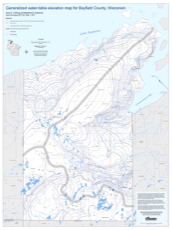
Generalized Water-Table Elevation Map for Bayfield County, Wisconsin [plate 1]
2017
Plate: 30 in x 40 in, scale 1:100,000
-
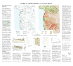
Preliminary Hydrogeologic Maps of Iowa County, Wisconsin
Open-file report; contains unpublished data that has not yet been peer-reviewed.-
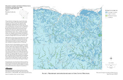
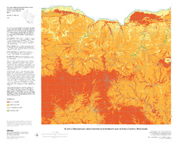
Preliminary Hydrogeologic Maps of Iowa County, Wisconsin: Preliminary Groundwater Recharge in Iowa County, Wisconsin [figure 1]
2010
Map: 28 in x 22 in, scale 1:225,000
-
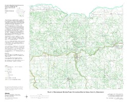
Preliminary Hydrogeologic Maps of Iowa County, Wisconsin: Preliminary Water-Table Elevation Map of Iowa County, Wisconsin [plate 1]
2010
Map: 26 in x 21 in, scale 1:100,000
-
Preliminary Hydrogeologic Maps of Iowa County, Wisconsin: Preliminary Groundwater Susceptibility Map of Iowa County, Wisconsin [plate 2]
2010
Map: 26 in x 21 in, scale 1:100,000
-
-
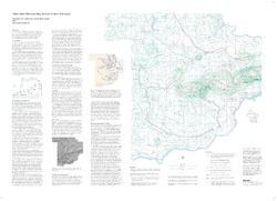
Hydrogeologic Atlas of Bayfield County, Wisconsin
Analysis of the groundwater resources in Bayfield County, Wisconsin. Includes report, five plates, and digital data.-
Generalized Water-Table Elevation Map of Bayfield County, Wisconsin [plate 1]
2019
Plate: 29.5 in x 39.5 in, scale 1:100,000
-
Depth to Water Table Map of Bayfield County, Wisconsin [plate 2]
2019
Plate: 29.5 in x 39.5 in, scale 1:100,000
-
Depth to Bedrock Map of Bayfield County, Wisconsin [plate 3]
2019
Plate: 29.5 in x 39.5 in, scale 1:100,000
-
Groundwater Recharge Map of Bayfield County, Wisconsin [plate 4]
2019
Plate: 29.5 in x 39.5 in, scale 1:100,000
-
Groundwater Susceptibility Map of Bayfield County, Wisconsin [plate 5]
2019
Plate: 29.5 in x 39.5 in, scale 1:100,000
-
Evaluation of the Solute Transport Model Developed for the Proposed Crandon Mine Tailings Management Area and Reclaim Pond
Open-file report; contains unpublished data that has not yet been peer-reviewed. -
Assessment of Virus Presence and Potential Virus Pathways in Deep Municipal Wells
Open-file report; contains unpublished data that has not yet been peer-reviewed. -
Mineral Transformation and Release of Arsenic to Solution under the Oxidizing Conditions of Well Disinfection
Open-file report; contains unpublished data that has not yet been peer-reviewed. -
Evaluation of the Reflooded Mine Solute Transport Model Developed for the Proposed Crandon Mine, Forest County, Wisconsin
Open-file report; contains unpublished data that has not yet been peer-reviewed. -
Delineation of Zones of Contribution for Municipal Wells in Sauk County, Wisconsin: Final Report
Open-file report; contains unpublished data that has not yet been peer-reviewed.-
Delineation of Zones of Contribution for Municipal Wells in Sauk County, Wisconsin
2002
Report: 74 p. + 2 plates
-
-
Delineation of Zones of Contribution for Municipal Wells in Rock County, Wisconsin: Final Report
Open-file report; contains unpublished data that has not yet been peer-reviewed. -
Sources of naturally occurring chromium in bedrock aquifers underlying Madison, Wisconsin
Open-file report; contains unpublished data that has not yet been peer-reviewed.-
Sources of Naturally Occurring Chromium in Bedrock Aquifers Underlying Madison, Wisconsin [appendices]
2012
Data: Data files (tab-delimited)
-
Human Viruses as Tracers of Wastewater Pathways into Deep Municipal Wells
Open-file report; contains unpublished data that has not yet been peer-reviewed.

Publications Catalog
Wisconsin Geological and Natural History Survey