-
The Underground and Surface Water Supplies of Wisconsin
-
Geologic Map of Wisconsin Showing Artesian Conditions and Elevations of the Pre-Cambrian [plate 1]
1915
Map: 15.5 in x 16.9 in, scale 1:1,000,000
-
Sandstones of the Wisconsin Coast of Lake Superior
-
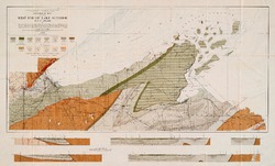
Geological Map of Part of West End of Lake Superior
1912
Map: 25.2 in x 15.2 in, scale 1 in = 3 miles

Publications Catalog
Wisconsin Geological and Natural History Survey