-
A Summary of Geology and Mineral and Water Resources of Rock County
Open-file report; contains unpublished data that has not yet been peer-reviewed. -
Availability of Ground Water for Municipal Supply at New Richmond, St. Croix County, Wisconsin
Open-file report; contains unpublished data that has not yet been peer-reviewed. -
Availibility of Ground Water for Municipal Supply at Woodville, St. Croix County, Wisconsin
Open-file report; contains unpublished data that has not yet been peer-reviewed. -
Geology and Ground Water of the Trout Lake Region, Vilas County, Wisconsin
Open-file report; contains unpublished data that has not yet been peer-reviewed. -
Central Sands Lakes Study: Annotated Bibliography
The authors of this open-file report scoured the literature for previous studies about the Central Sands area. This bibliography provides an overview of available research related to the hydrogeologic setting and water-budget components of the Central Sands Lakes Study (CSLS). -
Portable X-Ray Fluorescence (pXRF) Measurements of Uranium and Thorium in Madison, Wisconsin, Water Utility Wells 4 and 27
Concentrations of radium at or above the health standard in a Madison municipal well prompted the water utility to request assistance from the Wisconsin Geological and Natural History Survey to better understand the source of the radium. This report documents a series of analyses performed on the elemental composition of rock samples from the affected...-
Portable X-Ray Fluorescence (pXRF) Measurements of Uranium and Thorium in Madison, Wisconsin, Water Utility Wells 4 and 27
2017
Report: 10 p. (report) + 28 p. (2 appendices)
-
-
Sources of naturally occurring chromium in bedrock aquifers underlying Madison, Wisconsin
Open-file report; contains unpublished data that has not yet been peer-reviewed.-
Sources of Naturally Occurring Chromium in Bedrock Aquifers Underlying Madison, Wisconsin [appendices]
2012
Data: Data files (tab-delimited)
-
Human Viruses as Tracers of Wastewater Pathways into Deep Municipal Wells
Open-file report; contains unpublished data that has not yet been peer-reviewed. -
Assessing the Ecological Status and Vulnerability of Springs in Wisconsin
Open-file report; contains unpublished data that has not yet been peer-reviewed.-
Assessing the Ecological Status and Vulnerability of Springs in Wisconsin [GIS Data]
2008
GIS Data: Shapefiles, JPEG images, Microsoft Access database
-
Source Term Review for the Tailings Management Area and Reclaim Pond at the Proposed Crandon Mine, Forest County, Wisconsin
Open-file report; contains unpublished data that has not yet been peer-reviewed. -
Verification and Characterization of a Fracture Network within the Maquoketa Shale Confining Unit, Southeastern Wisconsin
Open-file report; contains unpublished data that has not yet been peer-reviewed. -
Hydraulic Conductivity and Specific Storage of the Maquoketa Shale
Open-file report; contains unpublished data that has not yet been peer-reviewed. -
Hydrogeology of Dane County, Wisconsin
Open-file report; contains unpublished data that has not yet been peer-reviewed.-
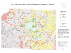
Water-Table Elevation and Unlithified Aquifers in Dane County, Wisconsin [plate 1]
1999
Map: 34.5 in x 25.5 in, scale 1:100,000
-
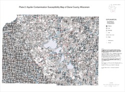
Aquifer Contamination Susceptibility Map of Dane County, Wisconsin [plate 2]
1999
Map: 34.5 in x 25.5 in, scale 1:100,000
-
Evaluation of the Confining Properties of the Maquoketa Formation in the SEWRPC Region of Southeastern Wisconsin: A Final Report Prepared for the Wisconsin Department of Natural Resources
Open-file report; contains unpublished data that has not yet been peer-reviewed. -
Variability of Nitrate Loading and Determination of Monitoring Frequency for a Shallow Sandy Aquifer, Arena, Wisconsin
Open-file report; contains unpublished data that has not yet been peer-reviewed. -
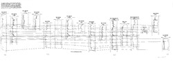
Correlation of High-Permeability Zones with Stratigraphic Features in the Silurian Dolomite, Sturgeon Bay, Wisconsin
Open-file report; contains unpublished data that has not yet been peer-reviewed.-
Correlation of High-Permeability Zones with Stratigraphic Features in the Silurian Dolomite, Sturgeon Bay, Wisconsin
1996
Report: 102 p. + 1 plate
-
-
Hydrogeologic and Land-Use Controls on Atrazine Detection in Dane County, Wisconsin
Open-file report; contains unpublished data that has not yet been peer-reviewed. -
Merging Pleistocene Lithostratigraphy with Geotechnical and Hydrogeologic Data--Examples from Eastern Wisconsin
Open-file report; contains unpublished data that has not yet been peer-reviewed. -
Maps Prepared as Overlays for Proposed Golf Course and Facilities North of Verona
Open-file report; contains unpublished data that has not yet been peer-reviewed. See WOFR1974-03 for companion report.-
Maps Prepared as Overlays for Proposed Golf Course and Facilities North of Verona
1975
Plate: 1 p. + 23 plates (1:24,000 scale)
-
-
Land Use and the Geologic and Hydrologic Environment in Parts of Middleton, Verona, Madison, and Fitchburg Townships, Dane County, Wisconsin
Open-file report; contains unpublished data that has not yet been peer-reviewed. See WOFR1975-02 for companion plates.

Publications Catalog
Wisconsin Geological and Natural History Survey