-
Inventory and Analysis of Flowing Artesian Wells in Bayfield County, Wisconsin
This report presents a county-wide inventory of flowing artesian wells in Bayfield County. Flowing artesian wells are a remarkable resource of high-quality water that both community members and tourists value. This report provides baseline water quality data that are a valuable resource for future assessments. Data collection occurred in 2022. Includes... -
Depth-to-Bedrock Mapping in Wisconsin
Depth-to-bedrock maps show the thickness of unconsolidated materials overlying bedrock. These maps provide a key link between the underlying geology, groundwater flow, and land use and are important in guiding activities such as permitting, bridge construction, and the land application of waste products in sensitive areas. Given their role in guiding... -
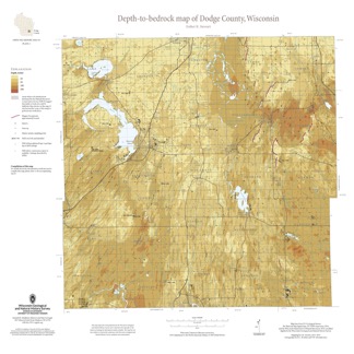
Depth-to-Bedrock Map of Dodge County, Wisconsin
This map shows thicknesses of deposits of unconsolidated materials above the bedrock. Across the county, depth to bedrock ranges from 0 feet, where bedrock is exposed, to over 250 feet within bedrock valleys. Areas with bedrock depths shallower than 20 feet are of particular importance for land-use planning and to the construction stone industry. Such... -
Geochemistry and Mineralogy of the Wonewoc-Tunnel City Contact Interval Strata in Western Wisconsin
Results of regional study characterizing the elemental composition of rocks found at the Wonewoc-Tunnel City contact interval in west-central and southwest Wisconsin.-
Geochemistry and Mineralogy of the Wonewoc-Tunnel City Contact Interval Strata in Western Wisconsin [appendices]
2019
Data: PDF files + Excel spreadsheet
-
Hydrologic Assessment of the Kickapoo Watershed, Southwestern Wisconsin
Open-file report; contains unpublished data that has not yet been peer-reviewed.-
Hydrologic Assessment of the Kickapoo Watershed, Southwestern Wisconsin
1998
Report: 81 p. + 4 plates
-
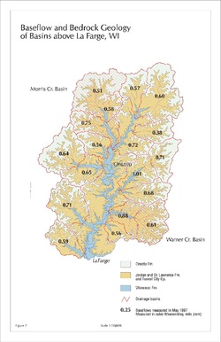
Baseflow and Bedrock Geology of Basins Above La Farge, WI [figure 7]
1998
Map: 11 in x 17 in, scale 1:150,000
-
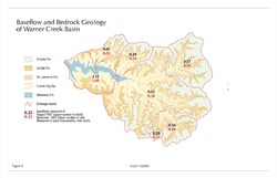
Baseflow and Bedrock Geology of Warner Creek Basin [figure 8]
1998
Map: 17 in x 11 in, scale 1:50,000
-
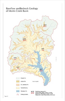
Baseflow and Bedrock Geology of Morris Creek Basin [figure 9]
1998
Map: 11 in x 17 in, scale 1:50,000
-
-
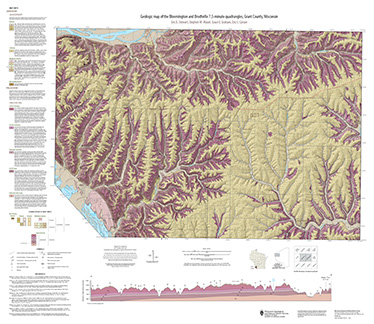
Geologic map of the Bloomington and Brodtville 7.5-minute quadrangles, Grant County, Wisconsin
The geologic map of the Bloomington and Brodtville quadrangles includes 1:24,000 scale mapping of both surficial and bedrock geology. There is little structural folding or faulting in this portion of the Driftless Area. Thus, it is ideal for studying the hydrostratigraphic framework of the mapped units. The accompanying report presents stratigraphic...-
Geologic map of the Bloomington and Brodtville 7.5-minute quadrangles, Grant County, Wisconsin
2022
Map: 41 in x 35 in, scale 1:24,000
-
GIS data for the geologic map of the Bloomington and Brodtville 7.5-minute quadrangles, Grant County, Wisconsin [dataset 1]
2022
GIS Data: File geodatabase
-
-
Geologic Map of the Fennimore and Mount Hope 7.5-Minute Quadrangles, Grant County, Wisconsin
The geologic map of the Fennimore and Mount Hope quadrangles includes 1:24,000-scale mapping of both surficial and bedrock geology. The mapping was initiated to support groundwater studies in the area. The map and accompanying report present the Paleozoic bedrock stratigraphy, including structures, as well as data from three new bedrock drill cores...-
Geologic Map of the Fennimore and Mount Hope 7.5-Minute Quadrangles, Grant County, Wisconsin
2023
Map: 50.55 x 36 in, scale 1:24,000
-
GIS Data for the Geologic Map of the Fennimore and Mount Hope 7.5-Minute Quadrangles, Grant County, Wisconsin [dataset 2]
2023
GIS Data: GeMS file geodatabase, metadata
-

Publications Catalog
Wisconsin Geological and Natural History Survey