-
Verification and Characterization of a Fracture Network within the Maquoketa Shale Confining Unit, Southeastern Wisconsin
Open-file report; contains unpublished data that has not yet been peer-reviewed. -
Field Verification of Capture Zones for Municipal Wells at Sturgeon Bay, Wisconsin: Final Report to the Wisconsin Department of Natural Resources
Open-file report; contains unpublished data that has not yet been peer-reviewed. -
Pleistocene Geology of Waukesha County, Wisconsin
-
Pleistocene Geology of Waukesha County, Wisconsin (version 2) [GIS data]
2001
GIS Data: GeMS file geodatabase (.gdb file format)
-
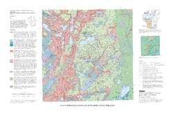
Pleistocene Geologic Map of Waukesha County, Wisconsin [plate 1]
2001
Map: 29 in x 19 in, scale 1:100,000
-
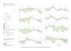
Pleistocene Geologic Cross Sections of Waukesha County, Wisconsin [plate 2]
2001
Plate: 25 in x 18 in, scale 1:200,000

Publications Catalog
Wisconsin Geological and Natural History Survey