-
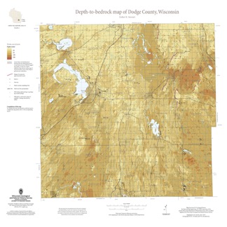
Depth-to-Bedrock Map of Dodge County, Wisconsin
This map shows thicknesses of deposits of unconsolidated materials above the bedrock. Across the county, depth to bedrock ranges from 0 feet, where bedrock is exposed, to over 250 feet within bedrock valleys. Areas with bedrock depths shallower than 20 feet are of particular importance for land-use planning and to the construction stone industry. Such... -
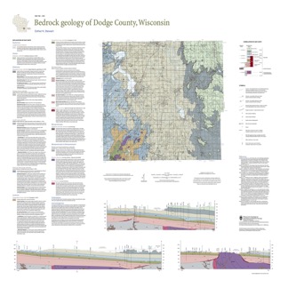
Bedrock Geology of Dodge County, Wisconsin
Dodge County lies in southeast Wisconsin, an area almost entirely covered by glacial deposits. This map interprets the distribution of the buried bedrock units across the county. Geologist Esther Stewart’s refinement of the bedrock elevation contours may help land-use planners identify areas most susceptible to groundwater contamination from applications...-
Supporting Data for the Bedrock Geology of Dodge County, Wisconsin
2021
Data: Spreadsheets (.xlsx file format)
-
GIS Data for the Bedrock Geology of Dodge County, Wisconsin [dataset 2]
2021
GIS Data: GeMS Level 3 file geodatabase (.gdb file format), shapefiles (.shp file format), GeoPackage (.gpkg file format)

Publications Catalog
Wisconsin Geological and Natural History Survey