-
Hydrogeology of the sandy uplands of the Bayfield Peninsula, Wisconsin
The sandy uplands of the Bayfield Peninsula are primary contributors to regional groundwater recharge and provide baseflow to streams in the area. Few data exist, however, to characterize upland hydrogeology or its susceptibility to groundwater contamination. Here, data from two new cores and wells, one existing well, and a lake in the sandy uplands...-
Rotosonic core data from the sandy uplands of the Bayfield Peninsula, Wisconsin [dataset 1]
2022
Data: Spreadsheets (.csv)
-
Water-level measurements from two monitoring wells in the sandy uplands of the Bayfield Peninsula, Wisconsin [dataset 2]
2022
Data: Spreadsheets (.csv)
-
Quaternary Geology of Jefferson County, Wisconsin
The Quaternary geologic map of Jefferson County, Wisconsin, provides details about the surficial sediment and landscapes that were formed largely in the footprint of the Laurentide Ice Sheet's southern Green Bay Lobe during the late Wisconsin Glaciation (ca. 20,000 years before present). These landscapes include lowlands underlain by glacial and...-
GIS Data for Quaternary Geology of Jefferson County, Wisconsin [dataset 1]
2022
GIS Data: GeMS file geodatabase, shapefiles, metadata
-
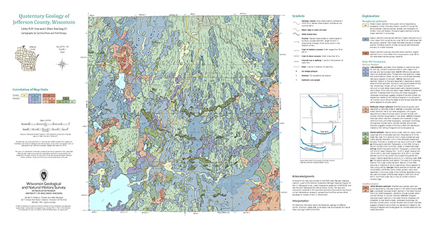
Quaternary Geology of Jefferson County, Wisconsin [plate 1]
2022
Map: 34.5 in x 18 in, scale 1:100,000

Publications Catalog
Wisconsin Geological and Natural History Survey