-
Quaternary Geology of Calumet and Manitowoc Counties, Wisconsin
All of what is now Calumet and Manitowoc Counties was covered by ice during the last great glaciation, between 30,000 and 11,000 years ago. This bulletin explains the glacial history, interprets the deposits left behind, and portrays the distribution of the deposits on a map and cross sections. This report should be useful to planners and development...-
Quaternary Geology of Calumet and Manitowoc Counties, Wisconsin [GIS data]
2017
GIS Data: Shapefiles (.shp file format)
-
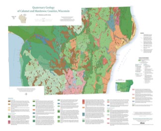
Quaternary Geology of Calumet and Manitowoc Counties, Wisconsin [plate 1]
2017
Plate: 35.5 in x 29 in, scale 1:100,000
-
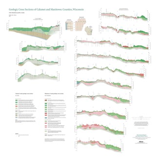
Geologic Cross Sections of Calumet and Manitowoc Counties, Wisconsin [plate 2]
2017
Plate: 36.67 in x 36.67 in, scale 1:100,000
-
Geology of Wisconsin - Outcrop Descriptions
These descriptions illustrate various geologic formations, features, and characteristics. Individual descriptions are one to ten pages long, and include a map with specific location, a description of geologic features, and a discussion of the geologic significance.-
Adams County: Upper Wisconsin Dells (T14N R6E Sec28)
Report: 3 p.
-
Adams County: Friendship Mound (T17N R6E Sec5)
Report: 2 p.
-
Adams County: Hamilton Mound (T20N R6E Sec36)
Report: 4 p.
-
Ashland County: Mt. Whittelsey (T44N R2W Sec9A)
Report: 3 p.
-
Ashland County: Mellen Gabbro (T45N R2W Sec30)
Report: 3 p.
-
Ashland County: Mellen Granite (T45N R2W Sec31)
Report: 3 p.
-
Ashland County: White River (T46N R4W Sec6)
Report: 2 p.
-
Bayfield County: South Fish Creek (T47N R5W Sec20)
Report: 2 p.
- 123 more...
-

Publications Catalog
Wisconsin Geological and Natural History Survey