-
Wisconsin Indoor Radon Data: 2010 Report of Data
Open-file report; contains unpublished data that has not yet been peer-reviewed.-
Wisconsin Indoor Radon Data: 2010 Report of Data [data]
2012
Data: Plain text files (.txt file format)
-
Statistical Analysis of Indoor Radon Data and Relationships to Geology in Wisconsin
Open-file report; contains unpublished data that has not yet been peer-reviewed. -
Middle Keweenawan Basin Evolution Inferred from Geophysical Analysis of Strongly Magnetic Intrusion, Clam Lake, Wisconsin
Open-file report; contains unpublished data that has not yet been peer-reviewed. -
Regional-Scale Geologic Interpretation of Seismic Reflection, Gravity and Magnetic Profiles Collected along the Western Arm of the Midcontinent Rift System, Upper Peninsula of Michigan, Wisconsin, Minnesota and Iowa
Open-file report; contains unpublished data that has not yet been peer-reviewed.-
Regional-Scale Geologic Interpretation of Seismic Reflection, Gravity, and Magnetic Profiles Collected Along the Western Arm of the Midcontinent Rift System, Upper Peninsula of Michigan, Wisconsin, Minnesota and Iowa
2002
Report: HTML interactive document (.html file format)
-
-
Preliminary Analysis of Aeromagnetic Data in Southern Wisconsin: The Role of Precambrian Basement in Paleozoic Evolution
Open-file report; contains unpublished data that has not yet been peer-reviewed.-
Preliminary Analysis of Aeromagnetic Data in Southern Wisconsin: The Role of Precambrian Basement in Paleozoic Evolution
2001
Data: Plain text files (.txt file format), documents (.pdf and .doc file formats), images (.jpg file format), spreadsheets (.xls file format)
-
-
International Geological Correlation Project 426: Granite Systems and Proterozoic Lithospheric Processes: 1998 International Field Conference: Proterozoic Granite Systems of the Penokean Terrane in Wisconsin
Open-file report; contains unpublished data that has not yet been peer-reviewed. -
Distribution of Radionuclides in Wisconsin Groundwater
Open-file report; contains unpublished data that has not yet been peer-reviewed. -
Gridded Aeromagnetic Data for Northern Wisconsin
Open-file report; contains unpublished data that has not yet been peer-reviewed. -
Evaluation of NURE Hydrogeochemical Data for Use in Wisconsin Groundwater Studies
Open-file report; contains unpublished data that has not yet been peer-reviewed. -
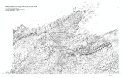
Summary of Field Mapping in the Superior Map Sheet, Wisconsin
Open-file report; contains unpublished data that has not yet been peer-reviewed. -
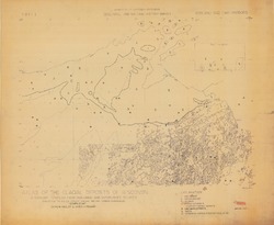
List of Earthquakes in Wisconsin
Open-file report; contains unpublished data that has not yet been peer-reviewed. -
Geologic Summary of the Ashland 2° Quadrangle
Open-file report; contains unpublished data that has not yet been peer-reviewed.-
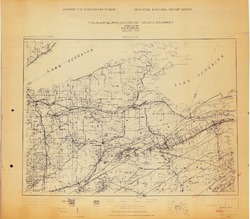
Preliminary Bedrock Geologic Map: Ashland Quadrangle
1979
Map: 4 p., 1 plate, 29.22 in x 25.65 in, scale 1:250,000
-
Geology of Wisconsin - Outcrop Descriptions
These descriptions illustrate various geologic formations, features, and characteristics. Individual descriptions are one to ten pages long, and include a map with specific location, a description of geologic features, and a discussion of the geologic significance.-
Adams County: Upper Wisconsin Dells (T14N R6E Sec28)
Report: 3 p.
-
Adams County: Friendship Mound (T17N R6E Sec5)
Report: 2 p.
-
Adams County: Hamilton Mound (T20N R6E Sec36)
Report: 4 p.
-
Ashland County: Mt. Whittelsey (T44N R2W Sec9A)
Report: 3 p.
-
Ashland County: Mellen Gabbro (T45N R2W Sec30)
Report: 3 p.
-
Ashland County: Mellen Granite (T45N R2W Sec31)
Report: 3 p.
-
Ashland County: White River (T46N R4W Sec6)
Report: 2 p.
-
Bayfield County: South Fish Creek (T47N R5W Sec20)
Report: 2 p.
- 123 more...
-
-
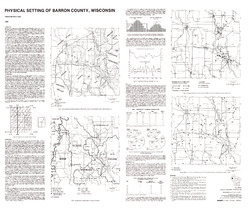
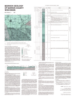
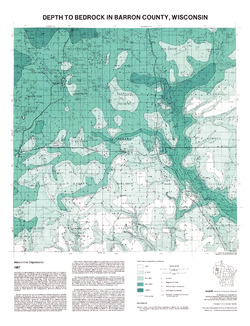
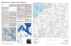
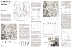
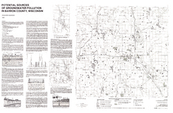
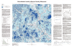
Atlas of Groundwater Resources and Geology of Barron County, Wisconsin
Includes Physical Setting; Soils of Barron County and Their Ability to Attenuate Pollutants; Bedrock Geology; Depth to Bedrock; Hydrogeology; Water Quality; Potential Sources of Groundwater Pollution; Groundwater Levels; Groundwater Pollution Potential.-
Atlas of Groundwater Resources and Geology of Barron County, Wisconsin: Soils of Barron County and Their Ability to Attenuate Pollutants
1987
Map: 30.8 in x 20.8 in, scale 1:100,000
-
Atlas of Groundwater Resources and Geology of Barron County, Wisconsin: Bedrock Geology of Barron County, Wisconsin
1987
Map: 21.5 in x 28.5 in, scale 1:250,000
-
Atlas of Groundwater Resources and Geology of Barron County, Wisconsin: Depth to Bedrock in Barron County, Wisconsin
1987
Map: 21.1 in x 27.6 in, scale 1:100,000
-
Atlas of Groundwater Resources and Geology of Barron County, Wisconsin: Hydrogeology of Barron County, Wisconsin
1987
Map: 37.5 in x 24.5 in, scale 1:100,000
-
Atlas of Groundwater Resources and Geology of Barron County, Wisconsin: Potential Sources of Groundwater Pollution in Barron County, Wisconsin
1987
Map: 35.75 in x 23.3 in, scale 1:100,000
-
Atlas of Groundwater Resources and Geology of Barron County, Wisconsin: Groundwater Levels in Barron County, Wisconsin
1987
Map: 35.8 in x 23.3 in, scale 1:100,000
-
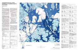
Atlas of Groundwater Resources and Geology of Barron County, Wisconsin: Groundwater Pollution Potential of Barron County, Wisconsin
1987
Map: 36.7 in x 24.25 in, scale 1:100,000
-
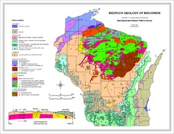
Bedrock Geology of Wisconsin, Northwest Sheet
Types of bedrock, formation names, major faults, and time period of formation.-
Bedrock Geology of Wisconsin, Northwest Sheet
1987
Map: 37.5 in x 22 in, scale 1:250,000; 35.5 in x 20 in
-
Bedrock Geology of Wisconsin, Northwest Sheet [GIS data]
1987
GIS Data: MrSID files (.sid file format)
-
-
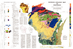
Bedrock Geologic Map of Wisconsin
Describes the types of rocks found throughout the state by age and explains how to interpret the accompanying cross section.-
Bedrock Geologic Map of Wisconsin [GIS data]
1982
GIS Data: MrSID files (.sid file format), coverage (.e00 file format)

Publications Catalog
Wisconsin Geological and Natural History Survey