-
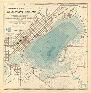
Hydrographic Map of Lake Monona, Dane County, Wisconsin, and of the Adjacent Topography
-
Hydrographic Map of Lake Monona, Dane County, Wisconsin, and of the Adjacent Topography
1900
Map: 18.7 in x 19.1 in, scale 1 in = 2,000 ft
-
-
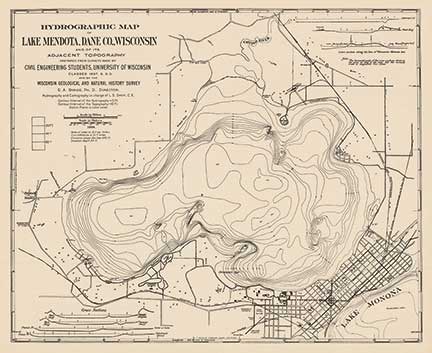
Hydrographic Map of Lake Mendota, Dane County, Wisconsin, and of Its Adjacent Topography
-
Hydrographic Map of Lake Mendota, Dane County, Wisconsin, and of Its Adjacent Topography
1900
Map: 24.9 in x 20.3 in, scale 1 in = 1/3 mile
-
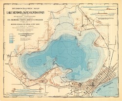
Hydrographic Map of Lake Mendota, Dane County, Wisconsin, and of Its Adjacent Topography
1900
Map: 24.9 in x 20.7 in, scale 1 in = 1/3 mile
-
-
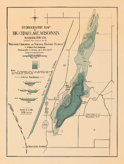
Hydrographic Map of Big Cedar Lake, Washington County
-
Hydrographic Map of Big Cedar Lake, Wisconsin, Washington County
1899
Map: 15 in x 19.9 in, scale 1 in = 1/4 mile
-
-
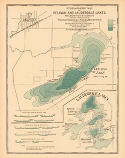
Hydrographic Map of Delavan and Lauderdale Lakes, Walworth County, Wisconsin
-
Hydrographic Map of Delavan and Lauderdale Lakes, Walworth County, Wisconsin
1898
Map: 18.8 in x 23.8 in, scale 1 in = 1/4 mile
-
-
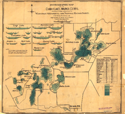
Hydrographic Map of the Chain-O'-Lakes, Waupaca County, Wisconsin
-
Hydrographic Map of the Chain-O'-Lakes, Waupaca County, Wisconsin
1898
Map: 22.8 in x 20.8 in, scale 1 in = 1/6 mile
-
-
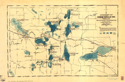
Hydrographic Map of the Oconomowoc-Waukesha Lake District, Waukesha County, Wisconsin
-
Hydrographic Map of the Oconomowoc-Waukesha Lake District, Waukesha County, Wisconsin
1898
Map: 34 in x 22.3 in, scale 1 in = 1/2 mile
-
-
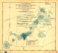
Hydrographic Map of Lake Beulah, Walworth County, Wisconsin, together with Booth and East Troy Lakes
-
Hydrographic Map of Lake Beulah, Walworth County, Wisconsin, Together With Booth and East Troy Lakes
1898
Map: 24.5 in x 22.4 in, scale 1 in = 1/6 mile
-
-
Hydrographic map of Elkhart Lake, Sheboygan County, Wisconsin
-
Hydrographic Map of Elkhart Lake, Sheboygan County, Wisconsin
1898
Map: 17.2 in x 14.1 in, scale 1 in = 1/7 mile
-

Publications Catalog
Wisconsin Geological and Natural History Survey