-
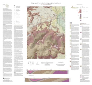
Geologic Map of the North Freedom 7.5-Minute Quadrangle, Sauk County, Wisconsin
The North Freedom quadrangle is located on the South Range of the Baraboo Hills in south-central Wisconsin. The Baraboo Hills are recognized for their ecologic and geologic significance, with superb exposure of Precambrian and Paleozoic rocks and Quaternary sediments. Mapping focused on the Precambrian section, building on past work by subdividing and...-
Geologic Map of the North Freedom 7.5-Minute Quadrangle, Sauk County, Wisconsin
2020
Map: 40 in x 37 in, scale 1:100,000
-
GIS Data for the Geologic Map of the North Freedom 7.5-Minute Quadrangle, Sauk County, Wisconsin (version 2) [dataset 1]
2020
GIS Data: GeMS file geodatabase (.gdb file format), shapefiles (.shp file format)
-
-
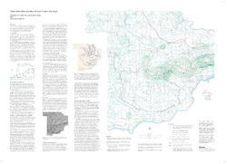
Water-Table Elevation Map of Sauk County, Wisconsin
-
Water-Table Elevation Map of Sauk County, Wisconsin [GIS data]
2002
Map: Coverage (.e00 file format)
-
Atlas of the Geological Survey of Wisconsin
Collection of most of the plates accompanying Chamberlin's four-volume Geology of Wisconsin: Survey of 1873-1879.-
Atlas of the Geological Survey of Wisconsin: General Geological Map of Wisconsin [plate 1]
1882
Map: 25.5 in x 30.3 in, scale 1 in = 15 miles
-
Atlas of the Geological Survey of Wisconsin: General Map of Quaternary Formations [plate 2]
1882
Map: 28.2 in x 32.4 in
-
Atlas of the Geological Survey of Wisconsin: General Map of Native Vegetation [plate 2A]
1882
Map: 28.2 in x 32.4 in
-
Atlas of the Geological Survey of Wisconsin: General Map of Soils [plate 2B]
1882
Map: 28.2 in x 32.5 in
-
Atlas of the Geological Survey of Wisconsin: Map of Rainfall and Temperature [plate 2C]
1882
Map: 27.7 in x 32.5 in
-
Atlas of the Geological Survey of Wisconsin: Maps of Subsoils and Native Vegetation of Eastern Wisconsin [plate 3]
1877
Map: 27.82 in x 32.17 in, scale 1 in = 12 miles
-
Atlas of the Geological Survey of Wisconsin: Maps of Topography and Quaternary Formations of Eastern Wisconsin [plate 4]
1877
Map: 27.83 in x 32.06 in, scale 1 in = 12 miles
-
Atlas of the Geological Survey of Wisconsin: Geology and Topography of the Lead Region [plate 5]
1877
Map: 27.68 in x 32.18 in
-
Atlas of the Geological Survey of Wisconsin: Geology and Topography of the Lead Region [plate 6]
1877
Map: 23.98 in x 28.94 in
-
Atlas of the Geological Survey of Wisconsin: Geology and Topography of the Lead Region [plate 8]
1877
Map: 24.03 in x 28.38 in
- 32 more...
-

Publications Catalog
Wisconsin Geological and Natural History Survey