-
Chequamegon-Nicolet National Forest Water Quality Database
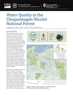
The Chequamegon-Nicolet National Forest (CNNF) in northern Wisconsin contains numerous groundwater-dependent water resources that may be vulnerable to potential effects of land development, mining, and climate change. In order to monitor water quality over time, 138 of the lakes, streams, wetlands, spring ponds, springs, and wells were sampled in...-
Chequamegon-Nicolet National Forest Water Quality Database
2024
Data: Spreadsheets (.csv file format)
-
-
Wisconsin Groundwater-Level Monitoring Network Improvements, 2018-2021
This report documents work completed as part of a grant from the U.S. Geological Survey’s National Groundwater Monitoring Network (NGWMN) program. It provides an overview of the Wisconsin Groundwater-Level Monitoring Network (WGLMN) and provides detailed description of well evaluation and repair activities, and drilling of new monitoring wells across the... -
Characterization of Groundwater Resources in the Chequamegon-Nicolet National Forest, Wisconsin
Results of a comprehensive review and analysis of groundwater resources in the Chequamegon-Nicolet National Forest. The study was divided by location into four reports corresponding to the four main land units: Medford, Nicolet, Park Falls, and Washburn/Great Divide. Each report describes the results of the inventory, modeling, and analysis.-
Characterization of Groundwater Resources in the Chequamegon-Nicolet National Forest, Wisconsin: Medford Unit [GIS data]
2018
GIS Data: File geodatabase (.gdb file format)
-
Characterization of Groundwater Resources in the Chequamegon-Nicolet National Forest, Wisconsin: Medford Unit [plates]
2018
Map: 10 maps, 11 in x 17 in
-
Characterization of Groundwater Resources in the Chequamegon-Nicolet National Forest, Wisconsin: Nicolet Unit [GIS data]
2018
GIS Data: File geodatabase (.gdb file format)
-
Characterization of Groundwater Resources in the Chequamegon-Nicolet National Forest, Wisconsin: Nicolet Unit [plates]
2018
Map: 20 maps (10 each, northern and southern Nicolet Unit), 11 in x 17 in
-
Characterization of Groundwater Resources in the Chequamegon-Nicolet National Forest, Wisconsin: Park Falls Unit [GIS data]
2018
GIS Data: File geodatabase (.gdb file format)
-
Characterization of Groundwater Resources in the Chequamegon-Nicolet National Forest, Wisconsin: Park Falls Unit [plates]
2018
Map: 10 maps, 11 in x 17 in
- 2 more...
-
Quaternary Geology in the Vicinity of the Bend Deposit, Taylor County, Wisconsin
Open-file report; contains unpublished data that has not yet been peer-reviewed. -
Stagnant Ice Landforms of the Chippewa Moraine, Taylor County, Wisconsin
Open-file report; contains unpublished data that has not yet been peer-reviewed. -
Bedrock Geology of Wisconsin, West-Central Sheet
Types of bedrock, formation names, major faults, and time period of formation.-
Bedrock Geology of Wisconsin, West-Central Sheet [GIS data]
1988
GIS Data: GeMS file geodatabase (.gdb file format)
-
Bedrock Geology of Wisconsin, Northwest Sheet
Types of bedrock, formation names, major faults, and time period of formation.-
Bedrock Geology of Wisconsin, Northwest Sheet
1987
Map: 37.5 in x 22 in, scale 1:250,000; 35.5 in x 20 in
-
Bedrock Geology of Wisconsin, Northwest Sheet [GIS data]
1987
GIS Data: MrSID files (.sid file format)
-
-
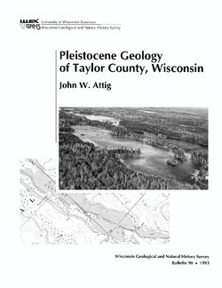
Pleistocene Geology of Taylor County, Wisconsin
-
Pleistocene Geology of Taylor County, Wisconsin (version 2) [GIS data]
1993
GIS Data: GeMS Level 3 file geodatabase (.gdb file format)
-
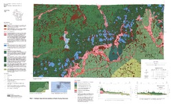
Geologic Map and Cross Sections of Taylor County, Wisconsin [plate 1]
1993
Map: 36 in x 21.75 in, scale 1:100,000
-
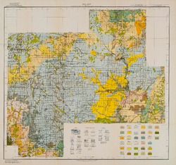
Reconnoissance [sic] Soil Survey of South Part of North Central Wisconsin
-
Soil Map: Wisconsin, Reconnoissance [sic] Survey - South Part of the North-Central Wisconsin Sheet
1918
Map: 20.5 in x 19.2 in, scale 1 in = 3 miles
-
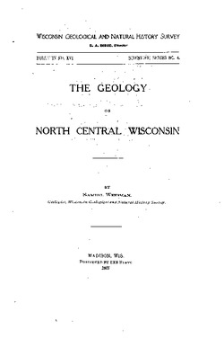
The Geology of North Central Wisconsin
-
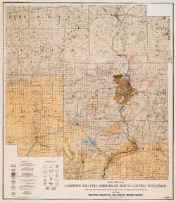
Map of the Cambrian and Pre-Cambrian of North Central Wisconsin: Clark, Wood, Portage, Marathon, Lincoln, Taylor and Parts of Langlade, Rusk and Price Counties [plate 1]
1907
Map: 20.0 in x 22.9 in, scale 1 in = 3 miles
-
Map of the Pleistocene of North Central Wisconsin: Clark, Wood, Portage, Marathon, Lincoln, Taylor and Parts of Langlade, Rusk and Price Counties [plate 2]
1907
Map: 20.1 in x 23.1 in, scale 1 in = 3 miles
-
Map Showing Rock Outcrops in Vicinity of Athens and Upper Rib River [plate 8]
1907
Map: 13.6 in x 8.8 in
-
Map Showing Rock Outcrops in Vicinity of Arpin and Junction City [plate 12]
1907
Map: 15.1 in x 9.9 in
-
Map Showing Rock Outcrops in Vicinity of Hewitt and Rozellville [plate 15]
1907
Map: 10.9 in x 7.5 in

Publications Catalog
Wisconsin Geological and Natural History Survey