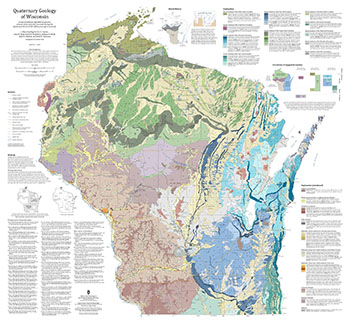
This 1:500,000 scale map of Wisconsin depicts sediment deposited by glaciers, streams, wind, and other processes during the Quaternary Period (2.58 million years ago to present). The map was made by compiling detailed Quaternary mapping and lithostratigraphic studies previously conducted by the WGNHS to generate consistent statewide Quaternary map units. This new compilation can be used to gain a broad understanding of surficial sediment across the state by both educational and scientific audiences. Published materials include a georeferenced map plate and GIS data in the geologic map schema (GeMS) format.