-
Evaluation of the Confining Properties of the Maquoketa Formation in the SEWRPC Region of Southeastern Wisconsin: A Final Report Prepared for the Wisconsin Department of Natural Resources
Open-file report; contains unpublished data that has not yet been peer-reviewed. -
Variability of Nitrate Loading and Determination of Monitoring Frequency for a Shallow Sandy Aquifer, Arena, Wisconsin
Open-file report; contains unpublished data that has not yet been peer-reviewed. -
Correlation of High-Permeability Zones with Stratigraphic Features in the Silurian Dolomite, Sturgeon Bay, Wisconsin
Open-file report; contains unpublished data that has not yet been peer-reviewed.-
Correlation of High-Permeability Zones with Stratigraphic Features in the Silurian Dolomite, Sturgeon Bay, Wisconsin
1996
Report: 102 p. + 1 plate
-
-
Hydrogeologic and Land-Use Controls on Atrazine Detection in Dane County, Wisconsin
Open-file report; contains unpublished data that has not yet been peer-reviewed. -
Merging Pleistocene Lithostratigraphy with Geotechnical and Hydrogeologic Data--Examples from Eastern Wisconsin
Open-file report; contains unpublished data that has not yet been peer-reviewed. -
Maps Prepared as Overlays for Proposed Golf Course and Facilities North of Verona
Open-file report; contains unpublished data that has not yet been peer-reviewed. See WOFR1974-03 for companion report.-
Maps Prepared as Overlays for Proposed Golf Course and Facilities North of Verona
1975
Plate: 1 p. + 23 plates (1:24,000 scale)
-
-
Land Use and the Geologic and Hydrologic Environment in Parts of Middleton, Verona, Madison, and Fitchburg Townships, Dane County, Wisconsin
Open-file report; contains unpublished data that has not yet been peer-reviewed. See WOFR1975-02 for companion plates. -
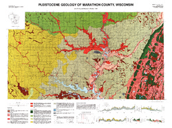
Pleistocene Geology of Marathon County, Wisconsin
-
Pleistocene Geology of Marathon County, Wisconsin (version 3) [GIS data]
1989
GIS Data: GeMS Level 3 file geodatabase and metadata. Supersedes previous GeMS Level 1 format (DI version 2).
-
Geoscience Wisconsin Volume 21
Age and correlation of Silurian rocks / Overview of Wisconsin's spring resources -
Geoscience Wisconsin Volume 06
-
A Summary of the Duval Massive Sulfide Deposit, Marinette County, Wisconsin
1982
Journal Article: p. 11-20
-
Some Aspects of the Petrologic and Tectonic History of the Precambrian Rocks of Waterloo, Wisconsin
1982
Journal Article: p. 21-40
-
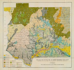
Reconnoissance [sic] Soil Survey of Part of North Western Wisconsin
-
Reconnoissance [sic] Soil Survey of Part of North Western Wisconsin (2nd edition)
1911
Report: 102 p. + map (scale 1 in = 3 miles)
-
-
Preliminary Report on the Soils and Agricultural Conditions of North Central Wisconsin
-
Preliminary Report on the Soils and Agricultural Conditions of North Central Wisconsin (2nd edition)
1903
Report: 72 p. + map (scale 1 in = 3 miles)
-
-
Inventory and Analysis of Flowing Artesian Wells in Bayfield County, Wisconsin
This report presents a county-wide inventory of flowing artesian wells in Bayfield County. Flowing artesian wells are a remarkable resource of high-quality water that both community members and tourists value. This report provides baseline water quality data that are a valuable resource for future assessments. Data collection occurred in 2022. Includes... -
Depth-to-Bedrock Mapping in Wisconsin
Depth-to-bedrock maps show the thickness of unconsolidated materials overlying bedrock. These maps provide a key link between the underlying geology, groundwater flow, and land use and are important in guiding activities such as permitting, bridge construction, and the land application of waste products in sensitive areas. Given their role in guiding... -
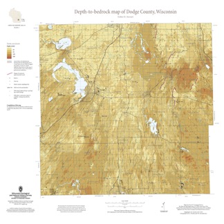
Depth-to-Bedrock Map of Dodge County, Wisconsin
This map shows thicknesses of deposits of unconsolidated materials above the bedrock. Across the county, depth to bedrock ranges from 0 feet, where bedrock is exposed, to over 250 feet within bedrock valleys. Areas with bedrock depths shallower than 20 feet are of particular importance for land-use planning and to the construction stone industry. Such... -
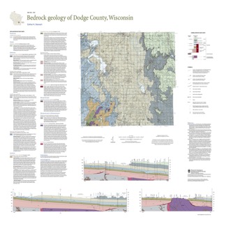
Bedrock Geology of Dodge County, Wisconsin
Dodge County lies in southeast Wisconsin, an area almost entirely covered by glacial deposits. This map interprets the distribution of the buried bedrock units across the county. Geologist Esther Stewart’s refinement of the bedrock elevation contours may help land-use planners identify areas most susceptible to groundwater contamination from applications...-
Supporting Data for the Bedrock Geology of Dodge County, Wisconsin
2021
Data: Tabular data files (Excel)
-
GIS Data for the Bedrock Geology of Dodge County, Wisconsin [dataset 2]
2021
GIS Data: GeMS file geodatabase, shapefiles, GeoPackage, and metadata
-
An Inventory of Springs in Wisconsin
Report, database, field protocol, photos, and site sketches documenting the multi-year project inventorying springs in Wisconsin with discharge rates of at least 0.25 cubic feet per second. -
Geochemistry and Mineralogy of the Wonewoc-Tunnel City Contact Interval Strata in Western Wisconsin
Results of regional study characterizing the elemental composition of rocks found at the Wonewoc-Tunnel City contact interval in west-central and southwest Wisconsin.-
Geochemistry and Mineralogy of the Wonewoc-Tunnel City Contact Interval Strata in Western Wisconsin [appendices]
2019
Data: PDF files + Excel spreadsheet
-
Hydrologic Assessment of the Kickapoo Watershed, Southwestern Wisconsin
Open-file report; contains unpublished data that has not yet been peer-reviewed.-
Hydrologic Assessment of the Kickapoo Watershed, Southwestern Wisconsin
1998
Report: 81 p. + 4 plates
-
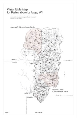
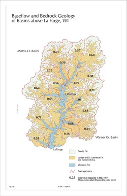
Baseflow and Bedrock Geology of Basins Above La Farge, WI [figure 7]
1998
Map: 11 in x 17 in, scale 1:150,000
-
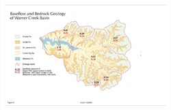
Baseflow and Bedrock Geology of Warner Creek Basin [figure 8]
1998
Map: 17 in x 11 in, scale 1:50,000
-
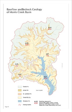
Baseflow and Bedrock Geology of Morris Creek Basin [figure 9]
1998
Map: 11 in x 17 in, scale 1:50,000
-
-
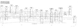
Water Resources of Wisconsin - Rock-Fox River Basin, Hydrologic Investigations Atlas HA-360
-
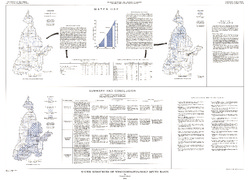
Water Resources of Wisconsin, Fox-Wolf River Basin: Plate 1, Physical Setting, Water System
1968
Plate: 38 in x 27.25 in
-
Water Resources of Wisconsin, Fox-Wolf River Basin: Plate 2, Ground Water
1968
Plate: 38 in x 27.25 in
-

Publications Catalog
Wisconsin Geological and Natural History Survey