-
Pleistocene Geology of Southern Wisconsin
Field trip guide with special papers by R.F. Black, N.K. Bleuer, F.D. Hole, N.P. Lasca, and L.J. Maher, Jr., 1970, 175 p. -
Geology of the Baraboo District, Wisconsin: A Description and Field Guide Incorporating Structural Analysis of the Precambrian Rocks and Sedimentologic Studies of the Paleozoic Strata
With summaries: Glacial Geology, R.F. Black; and Plant Ecology of the Baraboo Hills, J.H. Zimmerman.-
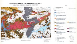
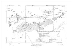
Geologic Map of the Baraboo District, Columbia and Sauk Counties, Wisconsin [plate 1]
1970
Map: 39.5 in x 22.7 in, scale 1:62,500
-
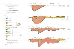
Geologic Cross Sections of the Baraboo District, Columbia and Sauk Counties, Wisconsin [plate 2]
1970
Plate: 32 in x 21 in
-
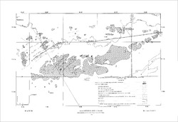
Map of Main Phase Minor Structures in the Baraboo Syncline, Columbia and Sauk Counties, Wisconsin [plate 3]
1970
Map: 31.5 in x 21.5 in
-
Structural Map of the Baraboo Syncline, Columbia and Sauk Counties, Wisconsin [plate 4]
1970
Map: 31.5 in x 21.5 in
-
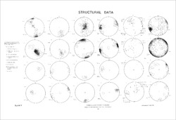
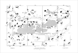
Structural Data: Lower Hemisphere Equal-Area Stereoplots of Structural Elements in the Baraboo Quartzite [plate 5]
1970
Plate: 31.5 in x 21.5 in
-
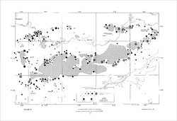
Orientations of Cross Stratification in Cambrian and Ordovician Sandstones [plate 7]
1970
Map: 31.5 in x 21.5 in
-
Geoscience Wisconsin Volume 17
-
Paleoecology and Sedimentology of the Prasopora Zonule in the Dunleith Formation (Ordovician), Upper Mississippi Valley
2007
Journal Article: p. 11-20
-
Trace-Element Signatures and Tectonic Affinities of Proterozoic A-Type Granites and Rhyolites in Central Wisconsin
2007
Journal Article: p. 35-51
-
Coupled Modeling of Gravity and Aeromagnetic Data to Estimate Subsurface Basement Topography in Southeastern Wisconsin
2007
Journal Article: p. 53-64
-
Geoscience Wisconsin Volume 07
Late Pleistocene History of Southeastern Wisconsin-
Geoscience Wisconsin, Volume 7: Late Pleistocene History of Southeastern Wisconsin
1983
Journal: 111 p.
-
The Wadsworth Till Member of Illinois and the Equivalent Oak Creek Formation of Wisconsin
1983
Journal Article: p. 1-16
-
Quaternary Stratigraphy of the Lower Milwaukee and Menomonee River Valleys, Milwaukee, Wisconsin
1983
Journal Article: p. 24-42
-
The Effect of Lake-Level Fluctuations on the Geomorphic Evolution of the Lake Michigan Bluffs in Wisconsin
1983
Journal Article: p. 43-58
-
Wisconsinan Stratigraphy and Glacial Sequence in Southeastern Wisconsin
1983
Journal Article: p. 59-85
-
Fabric and Depositional Structures in Drumlins near Waukesha, Wisconsin
1983
Journal Article: p. 98-111
-
-
Atlas of the Geological Survey of Wisconsin
Collection of most of the plates accompanying Chamberlin's four-volume Geology of Wisconsin: Survey of 1873-1879.-
Atlas of the Geological Survey of Wisconsin: General Geological Map of Wisconsin [plate 1]
1882
Map: 25.5 in x 30.3 in, scale 1 in = 15 miles
-
Atlas of the Geological Survey of Wisconsin: General Map of Quaternary Formations [plate 2]
1882
Map: 28.2 in x 32.4 in
-
Atlas of the Geological Survey of Wisconsin: General Map of Native Vegetation [plate 2A]
1882
Map: 28.2 in x 32.4 in
-
Atlas of the Geological Survey of Wisconsin: General Map of Soils [plate 2B]
1882
Map: 28.2 in x 32.5 in
-
Atlas of the Geological Survey of Wisconsin: Map of Rainfall and Temperature [plate 2C]
1882
Map: 27.7 in x 32.5 in
-
Atlas of the Geological Survey of Wisconsin: Maps of Subsoils and Native Vegetation of Eastern Wisconsin [plate 3]
1877
Map: 27.82 in x 32.17 in, scale 1 in = 12 miles
-
Atlas of the Geological Survey of Wisconsin: Maps of Topography and Quaternary Formations of Eastern Wisconsin [plate 4]
1877
Map: 27.83 in x 32.06 in, scale 1 in = 12 miles
-
Atlas of the Geological Survey of Wisconsin: Geology and Topography of the Lead Region [plate 5]
1877
Map: 27.68 in x 32.18 in
-
Atlas of the Geological Survey of Wisconsin: Geology and Topography of the Lead Region [plate 6]
1877
Map: 23.98 in x 28.94 in
-
Atlas of the Geological Survey of Wisconsin: Geology and Topography of the Lead Region [plate 8]
1877
Map: 24.03 in x 28.38 in
- 32 more...
-
-
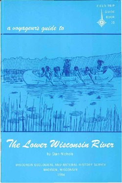
A Voyageur's Guide to the Lower Wisconsin River
This booklet covers the Wisconsin River from Prairie du Sac to the Mississippi River. It is a traveler’s guide, with boating safety tips as well as an educational guide to the history and natural history of the river. -
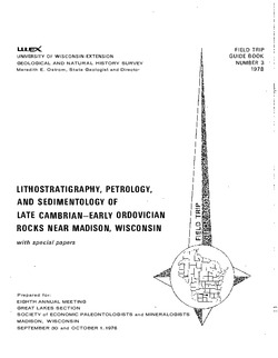
Lithostratigraphy, Petrology, and Sedimentology of Late Cambrian--Early Ordovician Rocks near Madison, Wisconsin
Prepared for 8th Annual Meeting, Great Lakes Section, Society of Economic Paleontologists and Mineralogists. -
The Baraboo Iron-Bearing District of Wisconsin
-
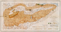
Geological Map of the Baraboo District, Wisconsin [plate 1]
1904
Map: 19.5 in x 10.3 in, scale 1 in = 1 mile vertical, 2 in = 1 mile horizontal
-
On the Lakes of Southeastern Wisconsin
-
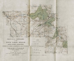
Pre-Glacial Topography of the Four Lakes Region, Dane County, Wisconsin: Showing Its Relation to the Existing Lakes and Streams [plate 37]
1910
Map: 11.6 in x 9.7 in, scale 1 in = 2 miles

Publications Catalog
Wisconsin Geological and Natural History Survey