-
Geology of Wisconsin - Outcrop Descriptions
These descriptions illustrate various geologic formations, features, and characteristics. Individual descriptions are one to ten pages long, and include a map with specific location, a description of geologic features, and a discussion of the geologic significance.-
Adams County: Upper Wisconsin Dells (T14N R6E Sec28)
Report: 3 p.
-
Adams County: Friendship Mound (T17N R6E Sec5)
Report: 2 p.
-
Adams County: Hamilton Mound (T20N R6E Sec36)
Report: 4 p.
-
Ashland County: Mt. Whittelsey (T44N R2W Sec9A)
Report: 3 p.
-
Ashland County: Mellen Gabbro (T45N R2W Sec30)
Report: 3 p.
-
Ashland County: Mellen Granite (T45N R2W Sec31)
Report: 3 p.
-
Ashland County: White River (T46N R4W Sec6)
Report: 2 p.
-
Bayfield County: South Fish Creek (T47N R5W Sec20)
Report: 2 p.
- 123 more...
-
-
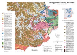
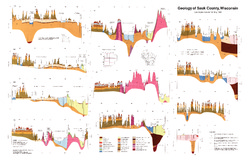
Geology of Sauk County, Wisconsin
Geologic history and description of Sauk County, the home of Devils Lake and Parfreys Glen. Includes four-color bedrock map and cross sections. Map and cross sections are folded.-
GIS Data for the Geology of Sauk County, Wisconsin (version 2) [dataset 1]
1990
GIS Data: GeMS Level 3 file geodatabase (.gdb file format), shapefiles (.shp file format)
-
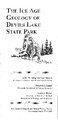
The Ice Age Geology of Devils Lake State Park
Devils Lake State Park is a place of striking geologic contrasts, where some of the oldest rock exposed in southern Wisconsin lies next to some of the youngest geologic materials in the state. The purple rock (called Baraboo quartzite) in the walls of Devils Lake gorge is more than 1.7 billion years old; the glacially deposited ridges that block both ends...-
The Ice Age Geology of Devils Lake State Park
1990
Report: 28 p., 1 plate, 18 in x 24 in, scale 1:24,000
-

Publications Catalog
Wisconsin Geological and Natural History Survey