
Quaternary Geology of Ozaukee and Washington Counties, Wisconsin
Data and Resources
-
Quaternary Geology of Ozaukee and Washington Counties, Wisconsin (version 2) [GIS data]
1997
GIS Data: GeMS Level 3 file geodatabase (.gdb file format)
-
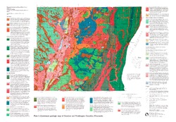
Quaternary Geologic Map of Ozaukee and Washington Counties, Wisconsin [plate 1]
1997
Map: 32.5 in x 22.5 in, scale 1:100,000
-
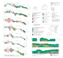
Geologic Cross Sections of Ozaukee and Washington Counties, Wisconsin [plate 2]
1997
Plate: 26 in x 24 in, scale 1:100,000
Related Collections
-

Bulletin
View Bulletin