
Quaternary Geology of Fond du Lac County, Wisconsin
Data and Resources
-
GIS Data for the Quaternary Geology of Fond du Lac County, Wisconsin [dataset 2]
2021
GIS Data: GeMS Level 3 file geodatabase (.gdb file format), shapefiles (.shp file format)
-
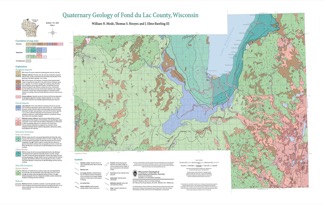
Quaternary Geology of Fond du Lac County, Wisconsin [plate 1]
2021
Map: 32 in x 20.25 in, scale 1:100,000
Related Collections
-

Bulletin
View Bulletin