-
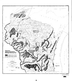
Groundwater Recharge in Menominee, Shawano, Waupaca, and Waushara Counties, Wisconsin, Estimated by a GIS-Based Water-Balance Model
This open-file report documents the recharge model created for the East Central Wisconsin Regional Planning Commission. Includes the resulting recharge map, a useful tool for land-use planners interested in identifying important groundwater recharge areas. -
Groundwater Recharge in Calumet, Outagamie, and Winnebago Counties, Wisconsin, Estimated by a GIS-Based Water-Balance Model
Open-file report; contains unpublished data that has not yet been peer-reviewed. -
Investigating Groundwater Recharge to the Cambrian-Ordovician Aquifer through Fine-Grained Glacial Deposits in the Fox River Valley
Open-file report; contains unpublished data that has not yet been peer-reviewed. -
Delineation of Areas Contributing Groundwater to Springs and Wetlands Supporting the Hine's Emerald Dragonfly, Door County, Wisconsin
Open-file report; contains unpublished data that has not yet been peer-reviewed. -
Groundwater Flow Model for the City of West Bend, Washington County, Wisconsin: Report to the City of West Bend, Wisconsin
Open-file report; contains unpublished data that has not yet been peer-reviewed. -
Investigation of the Effects of Recent Mine Closings on Ground-Water Quality and Quantity in the Shullsburg Area
Open-file report; contains unpublished data that has not yet been peer-reviewed.-
Investigation of the Effects of Recent Mine Closings on Ground-Water Quality and Quantity in the Shullsburg Area
1983
Report: 36 p. + 4 plates
-
-
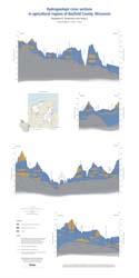
Groundwater and Wells in Agricultural Regions of Bayfield County, Wisconsin: Report to the Large-Scale Livestock Study Committee
Information and recommendations concerning groundwater and water supply wells in two agricultural regions in Bayfield County, Wisconsin. Includes a report, a water-table map, a set of four cross sections, and GIS data. (Replaces WOFR2015-02.)-
Groundwater and Wells in Agricultural Regions of Bayfield County, Wisconsin [GIS data]
2016
GIS Data: Shapefiles, metadata
-
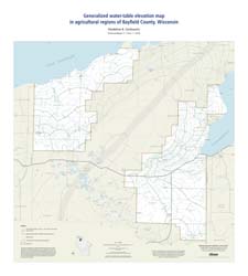
Generalized Water-Table Elevation Map in Agricultural Regions of Bayfield County, Wisconsin [plate 1]
2016
Map: 27 in x 30 in, scale 1:100,000
-
Hydrogeologic Cross Sections in Agricultural Regions of Bayfield County, Wisconsin [plate 2]
2016
Plate: 20.25 in x 40.25 in, scale 1:100,000
-
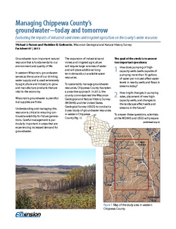
Managing Chippewa County's Groundwater--Today and Tomorrow: Evaluating the Impacts of Industrial Sand Mines and Irrigated Agriculture on the County's Water Resources
In 2012, Chippewa County commissioned the Wisconsin Geological Survey and the U.S. Geological Survey to conduct a 5-year study of the groundwater resources in the western part of the county. This 4-page publication describes the study and the computer models being developed for it. -
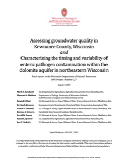
Assessing Groundwater Quality in Kewaunee County, Wisconsin, and Characterizing the Timing and Variability of Enteric Pathogen Contamination within the Dolomite Aquifer in Northeastern Wisconsin
Documentation of two studies looking at the Silurian dolomite aquifer in northeastern Wisconsin. Researchers quantified the extent of contamination from coliform bacteria, E. coli, and nitrate in Kewaunee County’s private wells. They also examined how wastewater from septic systems and livestock manure interact with environmental conditions and geology... -
Geoscience Wisconsin Volume 20
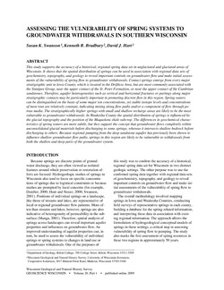
Vulnerability of spring systems to groundwater withdrawals in southern Wisconsin-
Assessing the Vulnerability of Spring Systems to Groundwater Withdrawals in Southern Wisconsin
2009
Journal Article: p. 1-13
-
Central Sands nitrate and neonicotinoids database
The Central Sands nitrate and neonicotinoid database consists of over 100,000 measurements of nitrate and neonicotinoid concentrations in groundwater from wells across Adams, Juneau, Marquette, Portage, Waushara, and Wood counties collected between 1953 and 2021. These counties comprise the Central Sands Groundwater County Collaborative (GSGCC), which... -
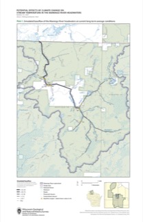
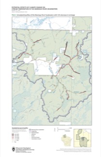
Potential Effects of Climate Change on Stream Temperature in the Marengo River Headwaters
Cold-water trout habitat in Wisconsin is projected to substantially decrease as a result of climate change. The extent of habitat loss depends, in part, on groundwater discharge to streams, which can provide cool-water refuges for trout. Survey hydrogeologists used field measurements and models of groundwater flow and stream temperature to evaluate how...-
GFLOW Groundwater Flow Model of the Marengo River Headwaters [dataset 1]
2021
Data: Groundwater flow model
-
Geodatabase - Three Baseflow Scenarios for the Marengo River Headwaters [dataset 2]
2021
GIS Data: File geodatabase
-
Measurements of Water Chemistry, Streamflow, and Stream Temperature from the Marengo River Headwaters [dataset 3]
2021
Data: Data (spreadsheets)
-
Simulated Baseflow of the Marengo River Headwaters with 21% Increase in Recharge [plate 2]
2021
Map: 11 in x 17 in
-
Simulated Baseflow of the Marengo River Headwaters with 12% Decrease in Recharge [plate 3]
2021
Map: 11 in x 17 in
-
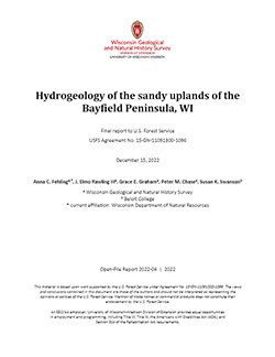
Hydrogeology of the sandy uplands of the Bayfield Peninsula, Wisconsin
The sandy uplands of the Bayfield Peninsula are primary contributors to regional groundwater recharge and provide baseflow to streams in the area. Few data exist, however, to characterize upland hydrogeology or its susceptibility to groundwater contamination. Here, data from two new cores and wells, one existing well, and a lake in the sandy uplands...-
Rotosonic core data from the sandy uplands of the Bayfield Peninsula, Wisconsin [dataset 1]
2022
Data: Spreadsheets (.csv)
-
Water-level measurements from two monitoring wells in the sandy uplands of the Bayfield Peninsula, Wisconsin [dataset 2]
2022
Data: Spreadsheets (.csv)
-
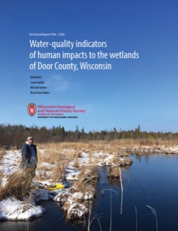
Water-Quality Indicators of Human Impacts to the Wetlands of Door County, Wisconsin
Door County, the narrow peninsula in eastern Wisconsin, is home to numerous wetlands, many of which are fed by groundwater. Poor-quality groundwater discharging to a wetland can alter the ecology of the wetland and harm native plant and animal communities. This report documents a one-year study of six wetlands. Researchers recorded water quality and... -
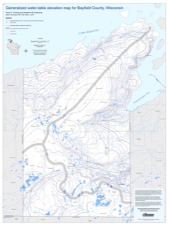
Bayfield County [Wisconsin] Water-Table Map and Water Well Database
This report provides information about well construction, groundwater flow, and resulting implications for well susceptibility in Bayfield County, Wisconsin. The work follows an earlier groundwater study that focused on two agricultural areas within Bayfield County.-
Generalized Water-Table Elevation Map for Bayfield County, Wisconsin [GIS data]
2017
GIS Data: Shapefiles
-
Generalized Water-Table Elevation Map for Bayfield County, Wisconsin [plate 1]
2017
Plate: 30 in x 40 in, scale 1:100,000
-
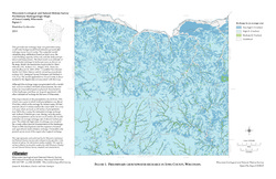
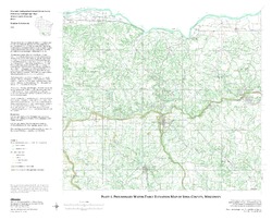
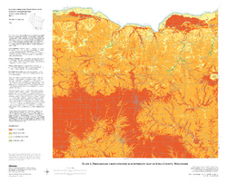
Preliminary Hydrogeologic Maps of Iowa County, Wisconsin
Open-file report; contains unpublished data that has not yet been peer-reviewed.-
Preliminary Hydrogeologic Maps of Iowa County, Wisconsin: Preliminary Groundwater Recharge in Iowa County, Wisconsin [figure 1]
2010
Map: 28 in x 22 in, scale 1:225,000
-
Preliminary Hydrogeologic Maps of Iowa County, Wisconsin: Preliminary Water-Table Elevation Map of Iowa County, Wisconsin [plate 1]
2010
Map: 26 in x 21 in, scale 1:100,000
-
Preliminary Hydrogeologic Maps of Iowa County, Wisconsin: Preliminary Groundwater Susceptibility Map of Iowa County, Wisconsin [plate 2]
2010
Map: 26 in x 21 in, scale 1:100,000
-
-
Assessing Seasonal Variations in Recharge and Water Quality in the Silurian Aquifer in Areas with Thicker Soil Cover
Documentation of variations in groundwater levels and selected water-quality parameters in four wells completed in the Silurian dolomite aquifer in northeast Wisconsin (Brown, Calumet, Kewaunee, and Manitowoc Counties).-
Assessing Seasonal Variations in Recharge and Water Quality in the Silurian Aquifer in Areas with Thicker Soil Cover
2019
Report: 38 p. + appendix (4 oversized pages)
-
-
Hydrogeological Characterization of the Town of Lincoln, Kewaunee County, Wisconsin
Report, maps, and GIS data cataloging the groundwater and hydrogeologic conditions in Kewaunee County's Town of Lincoln.-
Hydrogeological Characterization of the Town of Lincoln, Kewaunee County, Wisconsin
2017
Report: report (33 p.), 8 maps (11 in x 17 in, 1:50,000 scale), and appendix (15 p.)
-
Hydrogeological characterization of the Town of Lincoln, Kewaunee County, Wisconsin [GIS data]
2017
GIS Data: Shapefiles, metadata
-
-
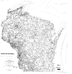
Ground Water Resources of Wisconsin
Open-file report; contains unpublished data that has not yet been peer-reviewed.

Publications Catalog
Wisconsin Geological and Natural History Survey